
 Abstract
- This paper presents an agent-based spatial simulation of shifting cultivation applied to savannah landscape in North-Cameroon (Duupa ethnic community). The model is based on empirical rules and was developed by a team who seek to create interdisciplinary dynamics by combining domain specific approaches to the same subject. The manner in which the model is described in this paper reflects the interdisciplinary processes that guided its development. It is made up of four domain-specific modules - demography, agriculture, savannah regrowth and social rules - which converge to form a fifth one, i.e., the evolution of the mosaic of cultivated fields. The focus is on how the spatial organization of landscapes results of environmental and social interactions. Two scenarios are presented in this paper. The first simulates the transformation of savannah woodland into a shifting cultivation savannah landscape. The second simulates changes in the landscape and socio-demographic structure of a Duupa village over a 60-year period. The simulation results are used to identify some of the key aspects of the socio-environmental interactions and help to explain why at large spatial scales and over a long period of time, the composition and structure of a landscape appear rather stable. For instance, it is well known that demography plays a key role in both social and environmental dynamics of shifting cultivation systems. Yet, in the case of the Duupa system, we show that social resilience can be acquired through interactions between demographic cycles of rising and falling population levels and a socioeconomic redistribution system. Finally, we compare the model developed with other shifting cultivation models and provide some insights on future developments.
- Keywords:
- Agent-Based Spatial Simulation, Social Resilience, Cameroon, Landscape Modeling, Shifting Cultivation
Landscape mosaic as the result of socio-environmental interactions
- 1.1
- Simulations of land cover dynamics provide land managers with a powerful tool to gain better insights into the key processes involved in these evolutions. They can used in land management decision making, while also generating plausible future scenarios. Agent based spatial simulations (ABSS) are often developed with these perspectives in mind. They are based on the assumption that the organization of space – referring to the structure and arrangement of physical objects and living beings on the surface of the earth – is the result of the combination of many processes occurring at different rates of behavior and at different spatial scales. Human activities are one of the key drivers of many of these processes, particularly in cultivated landscapes. At large spatial scales, and over a lengthy period, landscapes often appear rather stable in their composition and structure, while at a finer scale and over a shorter period, the rate of modifications can be higher. This may be due to land covers that evolve over time, according to an agronomic sequence. ABSS are designed to reproduce this pattern, as they enable the emergence of a stable spatial structure at a large scale based on the behavior of individual agents operating at a finer scale. Many of these models integrate a set of probabilistic rules on changes between land cover types (e.g. Gaucherel et al. 2006, Jepsen et al. 2006), and are constrained by biophysical rules. But, the social interactions between the people living in the landscape, managing its resources, and elaborating land sharing rules, in accordance with social and demographic constraints, are often less explicitly taken into account. This is despite the fact land management decision rules usually rely on these local communities and stakeholders.
- 1.2
- In line with Farina (2006), a landscape is not only the mosaic of land cover, it is also the combination of material (land covers) and non-material (social relations) properties. Adopting an approach that explicitly includes social processes within the simulation system is recommended in shifting agriculture since each new opening of crop fields in the savannah is the result of a new set of interactions between the different farmers sharing the same land. However, a stable pattern is observed at the landscape scale (Boserup 1965) despite the frequent changes in land cover and social interactions. Reproducing this pattern within agent-based simulations is a daunting challenge because it implies translating social rules within a spatial structure.
- 1.3
- The objective of the modeling is to build an interdisciplinary research process that will help us (i) validate our empirical knowledge of fundamental balances that exist between social system and environmental dynamics, (ii) generate new questions about the system under study, and thus contribute to a better understanding of the dynamics governing interactions occurring between cultivated savannahs, and their social, environmental and agricultural dimensions. The principal question we will address in this paper is: can we simulate the spatial organization of the Duupa landscape, and its evolution over time, with rules that govern interactions between the social and the environmental dynamics? To achieve this goal, we use a different modeling approach to those generally described in the literature on ABSS for shifting cultivation. These approaches usually aim to predict how landscape mosaics evolve by testing various assumptions such as in Gilruth et al. (1995).
- 1.4
- In this paper, we present an agent-based model (called MoPAgrIB) based on the shifting agriculture practiced by the Duupa community living in the north of Cameroon. In this region conflicts between nature conservation and population dynamics may arise in the future, and land managers must be able to address these issues. Social rules on interactions, recorded in ethnographic studies, are explicitly included in the model. After a description of the model, the results of a first scenario are presented to illustrate its capacity to reproduce the landscape mosaic observed in the Duupa community. A second scenario is designed to assess the long-term impacts of shifting cultivation on the landscape surrounding a specific Duupa village. The assessment criteria relate to the balances between social processes and environmental dynamics. Our conclusions underline the appropriateness of integrated social rules within the simulations and how interdisciplinary team work helped to identify crucial points in the modeling.
Multidisciplinary research on the Duupa territory and society
- 2.1
- For several years, a team of domain specialists (a geographer, anthropologist, agronomist and ecologist) have been working together on the Duupa territory in north Cameroon compiling significant quantities of data in each discipline (population census, aerial and satellite images, savannah vegetation characteristics, agricultural practices, social network, traditional religion etc…). The Duupa study site was chosen in part, because of the high level of biodiversity conserved under shifting cultivation. The area has been under cultivation for more than 300 years and despite changing population density levels, the floristic diversity observed today is equivalent to that measured in neighboring national parks such as Faro or Bénoué (Kokou et al. 2008). The Duupa community is made up of approximately 5,000 people living in scattered habitats (Figure 1). The research was mainly carried out in two Duupa villages. The first was located at the foot of the Poli massif (Wanté village) and the second in the mountains (Maambééba village). One of the most significant findings of this interdisciplinary research was the identification of 'field clusters' as an emergent property of the landscape mosaic under shifting cultivation.
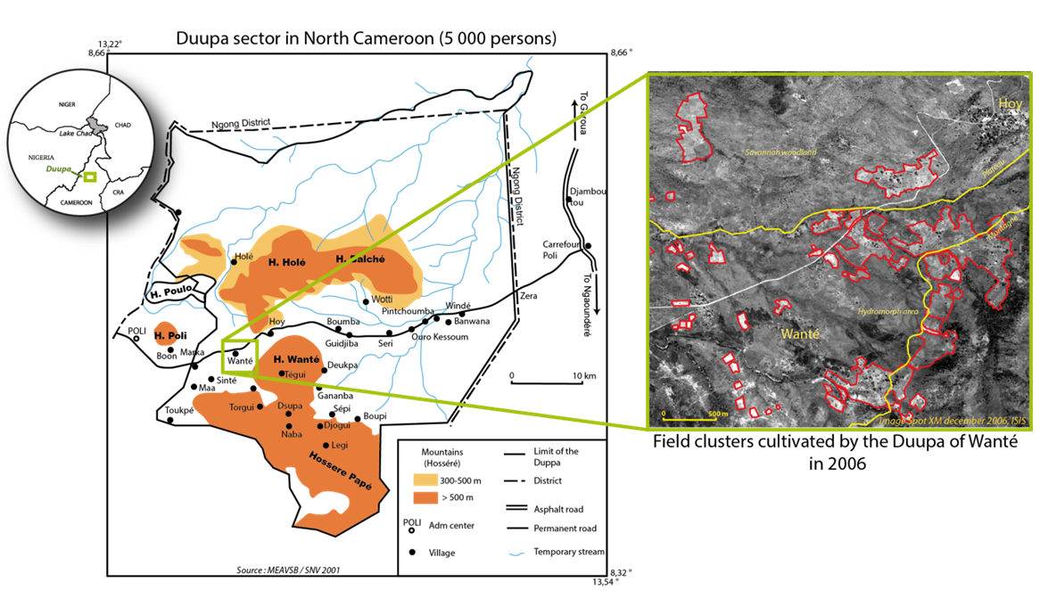
Figure 1. The Duupa territory located in the North Cameroon (left circle) is characterized by scattered settlements and cultivated patches (red polygons on the right aerial photograph) spread over the plain (between the two yellow lines), on the slopes of mountains (south of the lower yellow line), and on the plateau (north of the upper yellow line). - 2.2
- From a spatial organization perspective, the landscape of the Duupa territory is mainly characterized by cultivated patches of 2 to 10 ha. These are distributed throughout the savannah and possess no regular pattern that could be solely attributable to distances from the habitat, land ownership or soil quality (Raimond et al. 2007). These cultivated patches evolve over time: some grow in size, some shrink and then disappear, while others are found at apparently random locations. The patches are made up of individual fields of different sizes, all adjacent to one another and all having an edge shared with the savannah. This specific spatial organization is explained by the fact that farmers prefer to cultivate next to each other in order to facilitate collective work and risk sharing of damage caused by wild fauna (each field having one edge facing the savannah).
- 2.3
- These field clusters also reflect a specific social organization. They are usually composed of a handful of big fields, owned by influential farmers (big-men). These large fields are found with a number of smaller individual fields, owned by either independent farmers or clients who, as we explain later in the paper, depend on a bigman for their livelihood for several years. However, this organization is temporary as the farmer coalition, brought into being by the field cluster, collapses as soon as the cluster disappears from the landscape. A year later, when these farmers clear new fields, they tend to be scattered over the landscape, in different field clusters for which new coalitions are formed that may have no ties with previous coalitions. A field cluster generally lasts for 6 or 7 years and individual fields are cultivated for a maximum of 5 years. The life cycle of field clusters is longer than that of an individual plot, because in most field clusters some farmers act as initial cultivators, while others join the cluster 2 or 3 years later.
- 2.4
- For our model, the key features of the Duupa social structure are: its kinship system (patrilineal descent), the institution of communal agriculture work, and a shift in the individual social status based on the accumulation of wealth. The latter is acquired through goods and labor transactions. The Duupa community is mainly composed of sedentary farmers, cultivating in mountainous area or at the foot of mountain ranges. Their shifting cultivation practices imply the cultivation of fields for a period of about 4 to 5 years followed by a fallow period. This fallow period can range from 10 years, in very rare cases, to 20 years, which is more frequent, although even longer fallow periods have been observed. Market-oriented agriculture, such as cotton production, is rare and is not included in our analysis. Sorghum is the main cultivated crop. It is a staple of the Duupa diet along with peanuts and certain vegetables. Sorghum flour is either used for cooking or to prepare sorghum beer which plays a central role in Duupa social transactions (Garine et al. 2003). Indeed, all social and ritual occasions (exchange of services, communal work, and religious ceremonies tied to the ancestors) are based on the invitation to drink sorghum beer (Garine 2001). Sorghum fields (as well as a few other types of field that are not taken into account in this study) are grouped together within a set of 5 to 10 fields, each belonging to an individual farmer. They thus form a cluster which is the socio-geographic unit modeled in our interdisciplinary research. In order to form a cluster, farmers have informal discussions, often initiated by a bigman. A group is then formed of those who are currently interested in opening a new field, and of those who are familiar with the intended field location. The relation between Duupa people and their territory is also spiritual. Indeed, they believe that the spirits of their ancestors, who cultivated at a specific location in the past, are still present there. Therefore, when forming coalitions, farmers try to include descendants of the ancestors who used to cultivate at the intended field location, thereby obtaining the spirits' blessing. For the Duupa, land fertility is directly linked to the (positive or negative) intervention of their ancestors. .
Modeling framework
- 3.1
- In the literature, all ABSS on shifting cultivation are specifically concerned with describing the link between yields and fallow periods, and use methods with varying degrees of refinement (Gilruth et al. 1995, Walker 2003, Brown 2008, Wickramasuriya et al. 2009 for instance). This is because potential yield and labor investment are the two main factors considered when modeling the plot selection process. Jepsen et al. (2006) state 'When deciding where to locate a plot, the farmer has to trade-off between (1) choosing a plot with high productivity and (2) choosing a plot requiring low labor inputs'. In these models, agents have a perfect knowledge of the site productivity and labor requirements[1] for each cell of the map, and will choose the best option. In some cases like in Ngo et al. (2008) social characteristics such as education levels are also considered in the modeling of plot-selection decision-making. Mertz (2002) shows that the length of a fallow period is insufficient to explain crop yields in shifting cultivation contexts and that the structure and diversity of the vegetation should be also considered.
- 3.2
- We have chosen a different approach to model where a plot should be located. We opt for a minimalist representation to model vegetation dynamics and potential yields, but we explicitly integrate farmers' decision rules. These are based on biophysical constraints, but also on relationships between individuals such as their social positions or filiations. Our approach seeks to model negotiations between farmers for plot clearing and not just to optimize labor investments dedicated to cultivated areas and potential areas to be cleared as in Jepsen et al. (2006) or Ngo et al. (2008). By doing so, the collective decision process we describe may lead to solutions that are not necessarily optimal.
- 3.3
- In order to foster a shared perspective among the domain specialists involved in model development, we designed the core conceptual framework of the MoPAgrIB model at the very early stages of the project. It contains four domain-specific modules: a demographic module, an agricultural module, a post-cultural savannah regrowth module and a social rules module. These four modules converge to form a fifth one, namely the 'field cluster module' which is the emerging dynamic we seek to explain using this model (Figure 2). The main interactions between modules are:
- The evolution of social positions within the population in relation to family size and farming success;
- The memory of past cultivated locations that partly explains where farmers decide to cultivate and with whom;
- The dynamics governing savannah clearing and savannah regrowth specific to shifting cultivation practices.
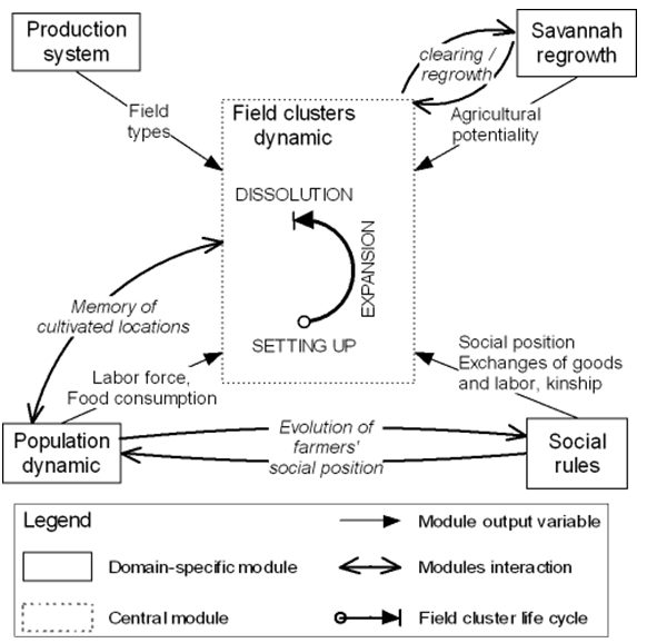
Figure 2. Overall model architecture defining field cluster dynamics as the result of domain-specific module outputs and module interactions
From the actual system to the conceptual model
- 4.1
- The MoPAgrIB model was developed under the Cormas platform (Bousquet et al. 1998). This platform is designed for natural resource management simulations[2]. MoPAgrIB model[3] runs on a yearly time step. The core social classes are a Farmer class and a Coalition class (Figure 3). The latter is temporary and defines a group of farmer-agents. These social classes correspond to two spatial classes: 'field' and 'field cluster' respectively. Similarly, 'field clusters' are defined as groups of fields, with the two further conditions that fields have to be adjacent and share an edge with the savannah. The model uses a spatial grid; with each cell corresponding to an area of 0.06 ha (fields are spatial aggregates of cells). The territory modeled represents an area of 15 km2.
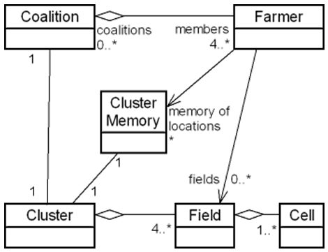
Figure 3. UML diagram showing the main classes of MoPAgrIB model and their associations - 4.2
- At each step, farmer-agents who are looking to clear a new field in the savannah send proposals to all other agents to join a coalition. These proposals refer to a particular location that the proposal sender knows and considers to be a suitable location. To do so, agents have a memory of locations (in the form of instances of ClusterMemory), which represents places where they, or their father, or close of kin, used to cultivate. Farmer-agents evaluate the proposals they receive and answer positively when they are also familiar with this location (because they are related to somebody who used to cultivate in this place). Proposals that receive a sufficient number of positive answers are finalized[4]. When the number of positive answers exceed the maximum number of farmers per coalition (less one - the sender of the proposal), the farmer-agents that will join the coalition are chosen randomly. The remaining farmers will have the opportunity to join another coalition as each farmer may answer several coalition proposals. Another constraint is also considered when finalizing a coalition: the initial proportion of bigmen in a coalition cannot exceed 50% (not including clients). This constraint reflects the specific social organization for farming of the Duupa people and was established based on a farmer census on actual field-clusters, which has been updated yearly since 2001. Resulting coalitions are then used by the program to sequence the clearing of the fields by the farmers – each field belonging to one field-cluster. Coalitions will last for a period of about 6 to 7 years, after which new coalitions will be formed. After a field-cluster collapse, a memory of it is generated in the form of an instance of the ClusterMemory class, and is added to the memory of each farmer that belonged to this cluster. Hence, the memory of locations is individualized and evolves over time.
- 4.3
- The following sections describe, in turn, the different modules of the model. At this stage of the model description, we have chosen not to follow the ODD protocol (Overview, Design concepts and Details) proposed by Grimm et al. (2010). Indeed, our aim in the following sections, besides explaining the mechanisms of the model, is to describe its interdisciplinary conception. To do so, we have chosen to present for each module: i) the empirical evidence and expert knowledge used by the domain specialist to describe the actual dynamics, ii) their transcription into a conceptual model and the modeling assumptions made. If we had followed the ODD protocol, which focuses on describing a model, we could not have shown as explicitly how the transition was made from the domain specialists' understanding of the actual system to the simulation model.
Post-cultural savannah regrowth module
Actual system
- 4.4
- Knowledge of the vegetation types of the savannah is fundamental as it is one of the main indicators used by Duupa farmers to evaluate the agricultural potential of an area and when deciding where to cultivate. Post-cultural savannah regrowth was studied in the territory of Wanté and Maambééba villages in 2003 by Kokou et al. (2008). They surveyed 68 abandoned plots. The duration of the fallow period was established through interviews with elder farmers, the type of vegetation observed (adult and subadult trees, bushes…), as well as through the type of soil, the vegetation cover surface, and other botanic and forestry indicators (trunk diameter, crown width and natural regeneration density) that were measured. Their findings show that, 20 years after abandonment, the vegetation found on a fallow land is similar to that a natural one, regardless of the geomorphology of the land. However, transitions from one type of intermediate vegetation cover to another occur at different moments, depending on the geomorphologic unit.
Conceptual model
- 4.5
- These results were formalized within the model using a state-transition model defining the different vegetation types and transitions depending on the different geomorphologic units (Figure 4). When abandoned, the vegetation is 'grass savannah', then after 5 years, it becomes 'shrub savannah'. Depending on the geomorphologic unit under study, it becomes 'tree savannah' after 10 to 15 years, and finally returns to 'savannah woodland' 20 years after abandonment. In this model, bush fires are implicitly accounted for as all the savannah areas are considered to be burnt at least once over a period of 5 years. This dynamic is implemented in the Cell class of MoPAgrIB model, and all cells perform it at the beginning of each step.
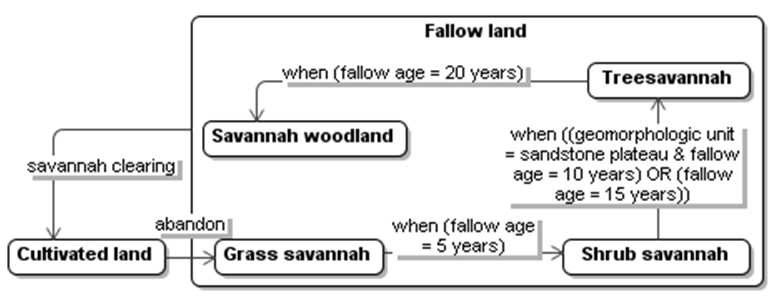
Figure 4. State-transition UML diagram of savannah regrowth Demographic module
Actual system
- 4.6
- Population renewal, family structures and weddings play crucial roles in the Duupa society. Having a large family, with many children, and frequently several wives, is positively viewed by the Duupa (Garine 1995; own survey 2008). A man with a large family will be considered successful and will see his reputation enhanced. Moreover, the size of the cultivated area and the types of plots will also be affected by the size of the family, because of its needs and labor potential. Finally, kinship relations play an important role in the social organization of farming practices and in the transmission of farming knowledge from one generation to the next. All these aspects strongly suggest that we must look at the demography at the individual level in order to represent social success as well as social dynamics related to agriculture.
Conceptual model
- 4.7
- Given the above requirements, we have chosen to model the demographic dynamic at the individual level contrary to most other ABSS on shifting cultivation, which tend to simulate demography at the household level. This modeling option is innovative and enables a very precise analysis of changes in the Duupa society. This is essential if one wishes to better understand farmers' collective decision-making processes. The model accounts for a population of individual agents. Each agent represents a person, with their own kinship ties, marriage and household membership. Birth and marriage events take place when an age condition, a minimum period between two similar events and a probabilistic condition are fulfilled. The probability condition, together with a birth spacing condition, is a standard way to model birthrates in an individual-based population model (Read 1998). In the case of marriage events, this probability represents what Duupa farmers call 'the chance to find a wife'. Parameters (birthrate, mortality, minimum age for marriage, birth spacing, etc.) are calibrated using data found in the literature (Read 1998) and direct observations. Marriage implies the migration of a woman from another village than the one considered in the model.
- 4.8
- Though, demographic dynamics are represented at the individual level, some procedures are aggregated at the household level. In the current version of the model, a household is considered to be a social group sharing food and labor. It includes a farmer, his wives, children and potentially other children he is in charge of. Household partitioning occurs when a child starts farming and thus forms a new household. A household disappears when the farmer dies, inducing the emigration of his wives and children (except for male children if they succeed in becoming farmers the same year their father dies). Net migration is equal to the immigration of spouses less the emigration of girls getting married outside the village and of children and spouses whose father or husband has passed away.
Agricultural module
Actual system
- 4.9
- Several campaigns of agricultural data collection have been conducted in the past years for the two studied villages, especially since 2001, based on satellite image interpretation and field surveys (Raimond et al. 2006). Results show that field diversity can be simplified and classified into 4 types according to their primary crop and crop rotation system: sorghum, peanuts, cotton fields and gardens (Table 1). Sorghum appears to be the most dominant field crop, covering almost three quarter of the agricultural landscape mosaic. The case of cotton is atypical as the main cotton producer of Cameroon has tried several times since 2001 to introduce this crop in the Wanté village; yet, until today, it has not gained traction with the local farmers. For instance, there were no cotton fields at all in the village in 2009–2010.
Table 1: Field types in Wanté village - average values from 2001 to 2003. In the years following this survey, cotton production was abandoned in this area by Duupa farmers Field type Crop rotation Field size % of the cultivated area Sorghum field 4 to 5 years sorghum cultivation, then abandoned 0.3 to 2.5 ha 72% Cotton field 1 year cotton followed by 1 year peanuts or maize 0.25 or 0.5 ha 15% Peanuts field 4 to 5 years peanuts cultivation, then abandoned 0.1 to 0.5 ha 11% Garden field Various crop associations cultivated continuously About 0.05 ha 2% Conceptual model
- 4.10
- In the current model version, we chose to model only sorghum fields. The area of a cultivated field is proportional to the labor force of the farmer-agent (family labor plus potential collective works). After a farmer-agent clears a piece of land, his activities consist in cultivating the field to obtain a certain grain yield at the end of each year based on his labour force. The annual yield per hectare is calculated as a random value[5] falling between the minimum yield and the maximum yield multiplied by a 'hardworker' factor estimated from the analysis of a farm sample (see formula below).

(1) Ymin the minimum potential yield per hectare (600 kg)
The random factor represents local hazards. The 'hardworker' factor represents the fact that some people are hardworkers and some not. After 4 to 5 years of cultivation, the sorghum field is abandoned and the agent may either look, with other available agents, for a location to start a new field cluster or join another existing coalition.
Ymax the maximum potential yield per hectare (900 kg)
H hardworker factor (equals to 1.15 for farmer-agents defined as hardworkers and to 1 for the others; 50% of farmer-agents are hardworkers)Social rules module
Actual system
- 4.11
- In the Duupa society, almost no monetary transactions occur in agricultural practices though the surplus of grain can be sold or converted into manufactured items and prestige goods like cattle, cloth and cotton pieces. These are important for ritual offerings (burials) and mostly for bridewealth payments. At the end of his life, most of the remaining wealth will be buried with its owner. A very simplified view of the accumulation process would depict conversion of agricultural surplus (grain) into prestige goods, which, in turn, are converted into 'wealth in persons', i.e., wives and children. This process reflects the gain in prestige and influence that allows an individual to attain the status of a bigman (called wãykeng or gbeee in the Duupa language). Young men begin their economic life as a bigman's 'client' (not necessarily their own father), by cultivating a little for themselves, while working for the bigman in the expectation of some reward such as prestige goods which are required in order to pay for the bridewealth of their first spouse. Once married, the ex 'client' gains the status of an 'independent farmer' and conducts his own economic strategy and sets his own agricultural agenda. One challenging objective of MoPAgrIB modeling is to account for the heterogeneity of actors' statuses and the shifts from one social position to another during the actors' lifetimes.
- 4.12
- Another outstanding feature of the Duupa agricultural system is the central role of communal work which involves the consumption of large quantity of sorghum beer and therefore of grain. Work parties are regularly organized on a reciprocal basis for all the farmers. If somebody wants some work done in his fields, he invites others to come and work for him for the day. Sorghum beer has to be offered to all the participants of the work party. Although beer is not conceptualized as a payment for the work, delayed reciprocation of work is the rule that underpins work exchange practices and the offering of beer (and related grain expenses) is a necessity. Friends, relatives or kin can be invited to work parties, but most of the actual exchange of work is accomplished within the network of farmers possessing adjoining fields within a cluster. When choosing a new field one must integrate the need to have good farm neighbors, i.e., people who are willing to join work parties and to reciprocate work and offer sorghum beer. Perfect reciprocity is not always achieved between partners of work parties and this can lead to conflicts between neighbors in the cluster. Those conflicts can, to a certain extent, explain why clusters break up after a few years, but good farm neighbors will cooperate and minimize conflicts.
Conceptual model
- 4.13
- Having no quantified data on how much grain is converted into the beer that is to be consumed during the following year's collective work (a form of reinvestment for the following year's farming activities) or how much is converted into prestige goods or saved for bridewealth, we opted for a simplified model. The model considers a quantity of sorghum grain for each agent used for all transactions. The annual harvest is primarily allocated to household food requirements and the remainder is split into two equal shares: the first for paying exchange labor for the following year, and the second is saved as prestige goods needed for bridewealth. In the case of a bigman, the share devoted to prestige goods is reduced to 40%[6] and another share of 33% is allocated to the clients of the bigman. This last share is designed to help clients collect enough prestige goods for them to marry after a couple of years (Figure 5). The more clients a bigman assists, the bigger the share dedicated to helping clients (N being the number of clients supported by a given bigman). Household food requirements are the sum of requirements of all the household members. The model considers four types of household member (child, teenager, adult woman and adult man) and for each of them a specific amount of grain is allocated per year per person based on Raimond et al. (2005).
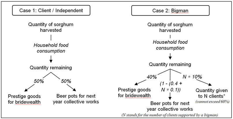
Figure 5. Simplified good transaction rules used in the MoPAgrIB model - 4.14
- The model to simulate the evolution of social positions is based on three types of social position (client, independent farmer and bigman). The transition from one social position to another is based on three criteria (family size, age and wealth) chosen according to our anthropological expertise regarding the system. The thresholds for these criteria were determined through statistical analysis of the social and economic data collected between 2001 and 2003. An agent, who is at first a child, becomes a farmer when he exceeds a certain age and when he is given the opportunity to start cultivating (Figure 6). This second condition is based on random criteria. Therefore, the age at which an agent becomes a farmer ranges between 16 and 25. We were very careful at this stage not to introduce any conditions concerning the number of clients and bigmen, as we wanted to test if the model would be able to reproduce the socio-economic equilibrium that exists between these two positions.
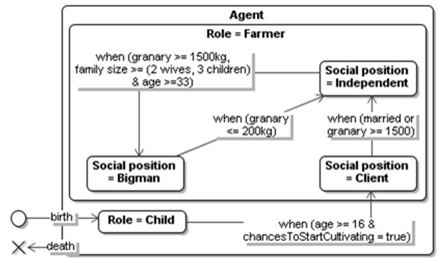
Figure 6. State-transition UML diagram defining the conditions required an agent to shift from one social position to another Indicators used
- 4.15
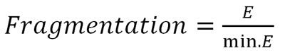
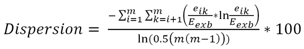
- Before describing the scenarios tested, we present the different output indicators used to analyze the simulation results. Most ABSS on shifting cultivation use indicators taken from landscape ecology in order to assess landscape organization (Gilruth et al. 1995, Deadman et al. 2004, Jepsen et al. 2006,Germaine and Puissant 2008). Among the different existing indicators, we chose to use fragmentation and dispersion indexes defined by the following equations.
(2) 
(3) E is the total length of edges in the landscape, including landscape borders
min.E is the minimum total length of edges in the landscape (equivalent to landscape's perimeter)
eik is the total length (m) of edges in the landscape between patch types (classes) i and k
Eexb is the total length of the edges in the landscape, excluding landscape borders
m is the number of patch types (classes) present in the landscape - 4.16
- Low fragmentation index values (1 to 4; 1 represents a landscape composed of a single patch) indicate a small number of large patches while high values (there is no absolute maximum for this index; in MoPAgrIB, 12 would be a maximum) refer to landscapes composed of many small patches (high edge density). For dispersion, high values (50 to 100) characterize landscapes in which patch types are distributed disproportionally or clumped. Low values (0 to 50) result from landscapes in which the patch types are adjacent to each other (Eiden et al. 2000). Figure 7 illustrates the concepts of patch and length of edges between patch types as used in equations 2 and 3.
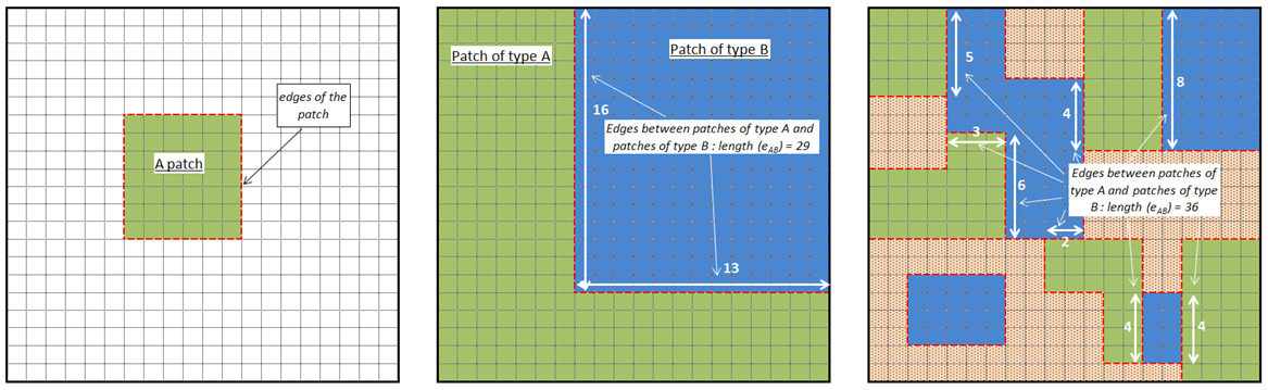
Figure 7. An example of patch, patch edges and length of edges between two types of patches - 4.17
- As for FAO (2000), we also use the percentage of potentially arable land actually in use, which is the ratio between utilized arable area (the actual cultivated area) and total potential arable area (land where soil and climate are suitable for growing crops, including forests, natural grasslands and areas classed as human settlement). According to FAO World Soil Resources Report (FAO 2000), in 1994 this percentage was equal to 14.2% for Sub-Saharan Africa and to 19.6% for Cameroon.
- 4.18
- For social and demographic outputs, we look at population size, family structure, the distribution of social positions as well as how much of the landscape is retained in the collective memory of the agent-farmers. This last indicator is the sum of the areas of the ClusterMemory instances (farmers' memory of past cultivated locations) recorded by agent-farmers at a given time step, divided by the total landscape area.
The frontier scenario: the emergence of a savannah mosaic under shifting cultivation
- 5.1
- A first scenario serves as a test to see if the model can simulate the emergence of a landscape mosaic based on environmental and social interactions. In this scenario, it is assumed that the landscape is initially uniform and entirely covered with savannah woodland. Hence, it is an 'artificial' landscape that is totally different from that of the Wanté village today. The only input data coming from Wanté village is the geomorphologic layer map. In this scenario, the simulation starts with no initial population, then from year one to year twelve, the model adds five families per year in the simulation. The simulation is run over a period of 60 years in order to observe the effect of immigrants on several generations. Each new family has one independent agent-farmer and is randomly composed of one or two wives and zero to three children. The memory of locations for newcomers is initialized with 2 instances of ClusterMemory (Figure 3) which are chosen randomly from among all the possible locations. This initialization simulates a situation for which newcomers have no prior w knowledge of the area (except 1 or 2 locations required for the model to be able to run), then increase their knowledge and update their memory as they cultivate in new places and colonize new territories. When a son starts farming, he then inherits from his father's knowledge a maximum of 6 memorized locations. On the other hand, when a person dies, his memory of locations is erased. If no other agents have memorized these locations, this means that they are lost for future generations.
- 5.2
- Simulation results show the apparition of a shifting cultivation savannah landscape based on a gradual stratification of vegetation types (grass savannah to savannah woodland) and the shifting of field clusters (Figure 8).
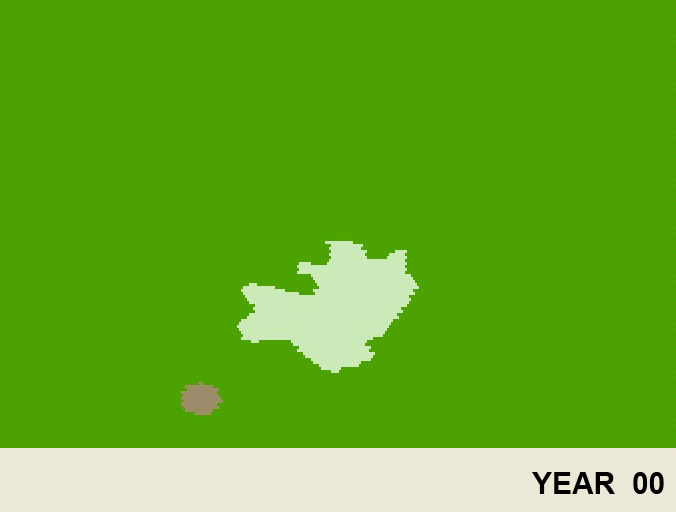
Figure 8. Animated picture covering 60 years simulation of the frontier scenario, showing the emergence of a shifting cultivation savannah landscape The percentage of potentially arable land in use rises from zero to 10% in the first 12 years and then stabilizes at around 15% which is a little lower than the national average. During the same period, the landscape becomes increasingly fragmented while the vegetation type patches are increasingly dispersed. Both landscape indicators seem to stabilize (Figure 9).
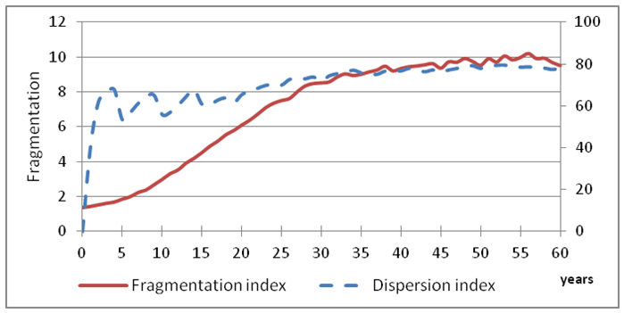
Figure 9. Evolution of landscape spatial organization indicators for the frontier scenario - 5.3
- Similarly, family structures change rapidly during the first 15 years and then follow a cyclical equilibrium. During the first years, the population structure is mainly made up of the newcomer families, which are composed of married men with one or more wives. After 8 to 10 years, a balance emerges between bachelor farmers on the one hand and large families on the other (Figure 10 – left). This balance enables upward mobility within the Duupa community (transfer of goods from bigmen to clients). Indeed, after 2 or 3 years, the first established farmers acquire the status of bigmen (Figure 10 – right) and are thus able to support the next new generation of young farmers (the older sons of the first newcomers) who, in return, will work part time for them as clients. As migration continues and the flow of young farmers increases, bigmen have to manage an increasing number of clients, resulting in a maximum of three or four clients per bigman (year 16). This ratio between clients and bigmen is not sustainable over the long term because bigmen who have too many clients are not able to support them correctly and are therefore forced to readopt an independent social position. This deviant behavior would lead, over the long term, to the disappearance of all bigmen. After the immigration flow ends, the ratio between clients and bigmen decreases and it takes 10 more years (until year 25 approximately) for a balance to be established between the bigmen and clients (Figure 10 – right), with one or two clients per bigman, as observed in the field. This result is especially interesting because it shows that with the rules and parameters we introduced in the model, the simulation tends to move towards equilibrium for family structures and social positions, which is what is observed today in the Wanté village.
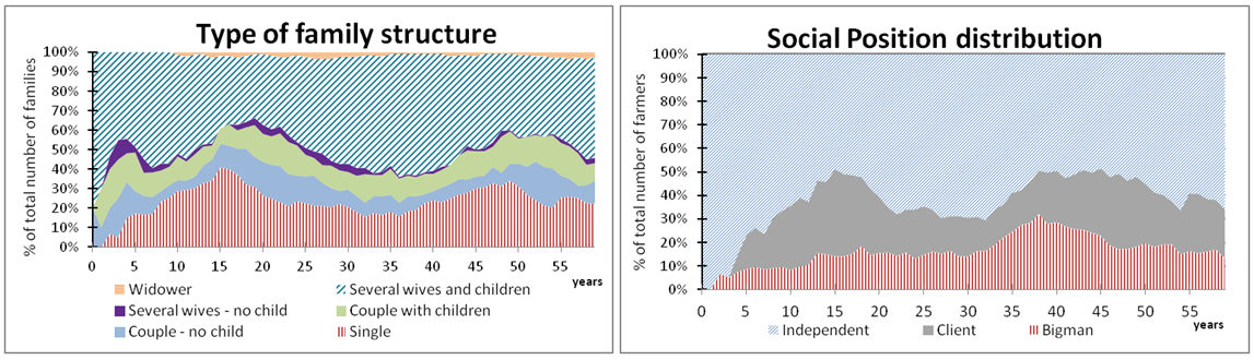
Figure 10. Evolution of social structure indicators for the frontier scenario - 5.4
- In terms of cluster composition, 6 is the median number of fields including, on average, one bigman's field (Figure 11 – left). Once again, this figure is similar to what is observed in Wanté village. At the expansion maximum, a cluster may be composed of more fields. Simulation results give a maximum of 14 fields. It is rare to see such large clusters in reality, but it may happen when a coalition comprised of many clients (with small fields) possess a large number of fields. However, such a big cluster is destined to be short-lived (a year at most). The size of each field depends on the farmer's labor force, and therefore varies according to the social position (Figure 11 – right) as observed in our case study. Before year 30, as the number of clients is high, the bigman's average field area rises above 3 hectares, and then drops to around 2.5 hectares, which is a standard field size for this social position in the Wanté village.
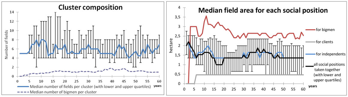
Figure 11. Evolution of field clusters composition and field area for the frontier scenario - 5.5
- This first scenario demonstrates the ability of the MoPAgrIB model to simulate the emergence of a shifting cultivation savannah landscape based on socio-environmental interactions. It allowed us to verify that simulation outputs, proportions of family structures and social positions, as well as composition and size of field clusters, match our observations on the field.
Simulating balances between social system and environmental dynamics in the current situation
- 6.1
- Over the past decades, the number of inhabitants of the Wanté village has remained rather stable (250–300 persons) in comparison to other areas of North Cameroon where significant migration flows have occurred. Similarly, our social surveys indicated regularities over-time in terms of social organization (e.g. a consistently small number of people playing the role of bigmen in the Duupa villages).
- 6.2
- From an environmental perspective, the data collected since 2001 show that biodiversity remains high and that human pressure on savannah has not increased. Nevertheless, the period of observation was short and simulation can help to prolong analysis over a longer period. The second scenario is designed to test, over a long period of time, our assumptions and empirical understanding of the balances that exist between social processes and environmental dynamics in the Duupa system. We want to assess the long-term impacts of shifting cultivation on the Wanté village landscape and to test if the composition and structure of the landscape will remain stable or not.
- 6.3
- For this purpose, the model is run for 60 years in order to cover three generations and three successive periods of savannah clearing and regrowth (the average observed fallow period being 20 years). After a 60-year simulation the results obtained do not reveal any new trends. The geomorphologic map used is the same as the one used for the previous scenario and the map of the initial vegetation types corresponds to the realities on the ground in 2006. To produce the map of savannah vegetation types, available maps of past cultivated areas (1968, 1991, 1999, 2003 and 2006) were combined to produce a map of the estimated length of the fallow period in 2006. Vegetation types were then derived from the previous map using the same rules as in Figure 4. A demographic census, which has been carried out in the Wanté village by Garine and Raimond since 2001, enabled us to estimate the population structure in 2006 and to define the initial population of the scenario. The population is made up of 270 persons, half of whom are children, includes 60 adult men (who are all farmers) and 80 adult women; 60% of households are polygamous, 25% are monogamous and 15% are home to single men.
- 6.4
- Based on this initial population, the farmers' social position at the beginning of the simulation is calculated using the state-transition rules defined in Figure 6, and generated the following results: 10 bigmen, 10 clients and 40 independents. The number of previously cultivated locations a farmer knows is calculated according to his age, representing 6 known locations when he starts farming (around age 20) plus one location for each additional 5-year age interval. Although our dataset on where farmers cultivate is exhaustive for all farmers of the Wanté village since 2001, it is still not enough to reconstitute the memory of past cultivated locations for the whole sample of agents of the simulation. To simulate the oral transmission of information about past uses of the territory, we chose at initialization to allocate locations to agents' memory. The locations are randomly chosen among a set of possible locations (one location being an aggregation of cells comprising an area of about 8 hectares. This area corresponds to the average size of a field cluster) and locations are distributed over the whole territory.
- 6.5
- The simulation results show the evolution of a cultivated savannah shaped by field clusters scattered over the landscape (Figure 12). Field clusters during the initialization period (as in detail α year 1), expand for a period of 5 or 6 years – with farmers joining the existing coalition and with independent farmers already in the coalition becoming bigmen – until it reaches a maximum size (as in detail β year 40) and finally collapse (detail γ year 10). The same location may be cultivated several times by the same farmers or their descendants (detail δ) where it has been cultivated once in year 1, a second time between year 20 and year 30 and a third time in year 60.
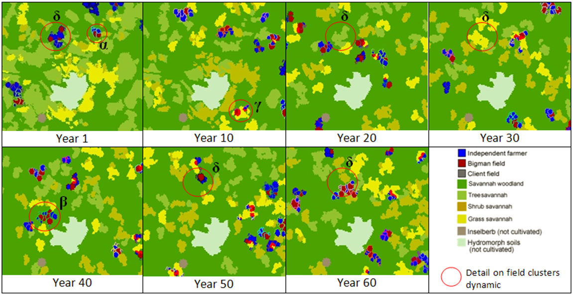
Figure 12. Spatial grid snapshots of landscape evolution over 60 years starting from the situation of the Wanté village in 2006 - 6.6
- With this scenario based on the current situation, spatial fragmentation and patch dispersion are lower than at the end of the simulation of the previous scenario (Figure 13 – left). This can be explained by the percentage of potentially arable land effectively in use, which is also lower in this simulation representing an average of 8%. This figure is much more in line with what we measured in the Wanté village as well as with what is observed in other shifting agriculture landscapes than the one generated for the previous scenario (15% of arable land used). The difference between the two scenarios is due to the size of the population, which is relatively constant in the present scenario, as we will see in the next paragraph, while it was constantly increasing in the previous scenario. The 2 point drop in the fragmentation index during the first 20 years reflects the disappearance of the initial large patches of tree savannah that can be seen in year 1. After year 20, the landscape is made up of smaller patches of tree, shrub and grass savannah, thus creating a larger space for woodland, which is abundant (Figure 13 – right). During the whole simulation, the proportion of cultivated area remains inferior to 5% of the total area. This corresponds to the reality of shifting cultivation in this region with a constant Duupa population. There are several possible explanations for this modification in landscape organization. It could be due to the low resolution of the landscape images used as input that could have induced a misinterpretation between savannah tree and woodland patches. Another explanation may be that the current model version only considers savannah vegetation types when simulating clearing practices; yet farmers also take into account other ecological characteristics when choosing a site for cultivation. Further investigations are therefore required to identify more precisely the ecological factors taken into account by farmers when choosing a place for clearing. Nevertheless, the dispersion index, representing the extent to which the vegetation type patches are scattered over the landscape, remains stable during the whole simulation.
- 6.7
- These preliminary results allowed us to verify that the assumptions we made on the functioning of the ecological and agricultural system. They can thus be used to simulate the landscape organization and environmental dynamics observed for the Wanté village. It also shows that under present conditions, the composition and structure of the savannah landscape in the Wanté village remain stable over time.
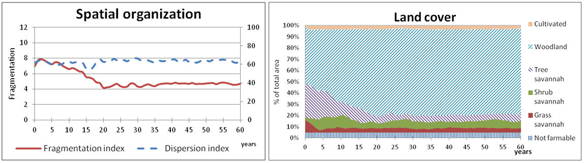
Figure 13. Spatial organization (left) of landscape and patch proportions (right) - current situation scenario - 6.8
- The second set of results on socio-demographic aspects, shows cycles of increasing rather than decreasing populations that fluctuate around an average population size close to the initial one (Figure 14). Emigration results from the death of a household head, which induces the departure of all family members. On the other hand, when young men get married there is a resulting immigration, followed a couple of years later by increased births. Yet, the net migration is most of the time negative and the population remains stable thanks to positive natural growth. As for the previous scenario, family structure and social position are closely related. In this simulation, population dynamics induced the death of many old farmers around year 30. The percentage of large households thus drops, as does the proportion of bigmen. During this transition phase, the number of clients per bigman first jumps to a maximum of 4, then drops back to 1 after 4–5 years, and finally stabilizes between 1 and 2 until the end of the simulation. This result is especially interesting because it demonstrates the ability of the model to reproduce the resilient nature of the Duupa socio-economic system. Indeed, if during the transition phase described here, the ratio between clients and bigmen had not decreased towards the end, the socio-economic system could have collapsed as explained for the previous scenario. Yet, the transition rules that link social position and demography allow the return to equilibrium as some clients get married during this period and thus become independent while some independent farmers become wealthy enough to become bigmen.
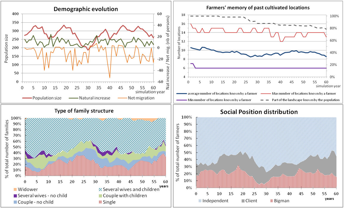
Figure 14. Demographic and social structure evolution - current situation scenario - 6.9
- The last simulation result we discuss here concerns farmer memory of past-cultivated locations which evolves during the simulation together with the movements of field clusters and generation shifts. The distribution of location knowledge within the population is heterogeneous and it is the oldest farmers who know the most locations (16 maximum, see Figure 14, top right). On average, the number of locations known per farmer is reduced from 10 to 8. Consequently, the proportion of the landscape known by all farmers, namely the collective memory, is depleted after the first generation (Figure 14, top right, dotted line). Hence, the simulation shows that, if we consider that past-cultivated locations are favored when deciding where to cultivate, then, when population density is relatively low as in the current situation, some areas may be lost from collective memory because they were not cultivated for a long period. Nevertheless, empirical evidence on the Duupa system or on similar agricultural systems in North Cameroon (Langlois et al. 2005) show that the entire territory has been cultivated at least once and that these locations are rarely entirely wiped from the collective memory. This means that the current model version is not able to capture the full complexity of the Duupa knowledge transmission system and that further investigations are therefore required.
Conclusion and perspectives
- 7.1
- The model development process and the analysis of simulation outputs greatly enriched the research activity of our multidisciplinary team. In this project, we are not interested in prediction, which would be vain, from our point of view, given the complexity of the dynamics involved. Rather, we see the benefit of developing MoPAgrIB as a process to stimulate interdisciplinary cohesion by combining domain specific perspectives around the same object, i.e., the landscape. This would allow us to generate new questions about the system under study and to identify knowledge gaps, before exploring new scenarios.
- 7.2
- One important factor that may explain the success of the interdisciplinary process is that we chose a common objective, right from the outset of the project. Our common goal was to share our knowledge on the dynamic of field clusters. This is why this component was placed at the heart of model interactions in the conceptual framework (Figure 2). Bousquet and Le Page (2004) underline the importance of an initial collective agreement among domain specialists in multidisciplinary modeling. Our modeling experience was based on this process and the identification of a number of crossover points between disciplines and conceptualizing efforts based on these shared areas of interest during the project's early intense collaboration phase proved to be especially efficient.
- 7.3
- The explicit modeling of the farmers' individual and collective decisions is one of the most innovative aspects of the MoPAgrIB model, when compared to other ABSS of shifting cultivating found in the literature. The model enabled us to conceptualize and test two fundamental equilibriums underpinning the efficient functioning of the Duupa system: the environmental equilibrium between farming practices and savannah regrowth and the socio-economic equilibrium between social positions that ensures upward social mobility. The model can therefore be used to assess scenarios dealing with the relations between farmers themselves. It can also be helpful when performing simulations to visualize the spatial footprint of social dynamics directly on the spatial grid of the model. The scenario simulating the emergence of a shifting cultivation savannah landscape teaches us that the socio-environmental equilibrium of the Duupa system is the result of a process that takes 30 to 40 years to stabilize. The second scenario, which simulated the evolution of the Wanté village from year 2006, suggests that given the present conditions and without external disturbances, the spatial organization of the savannah landscape in the Wanté village would remain stable over-time. This is especially important given, as already mentioned, the importance of this site in terms of biodiversity conservation.
- 7.4
- We were able to use MoPAgrIB to produce new knowledge on the influence of demography on the social resilience of the system. It is well known that demography does indeed play a key role in both the social and environmental dynamics of shifting cultivation systems, and that it is a very sensitive model parameter as demonstrated by Jouve (2004). Yet, the simulation results also show that social resilience can be acquired through interactions between demographic cycles of increasing and decreasing populations and a socioeconomic redistribution system.
- 7.5
- These results also raise the question of the carrying capacity of the Duupa system when attempting to assess how big a population the system could support before the social system collapsed or the ecological equilibrium broke down (Garine et al. 2005). These investigations are especially important for land management when one considers the expansion of agricultural areas in North Cameroon and that will most probably reach the Duupa territory sooner or later. These changes generate conflicting interests between natural conservation and agricultural production and our work can also be useful when addressing these issues. In this context, and with further development, the MoPAgrIB model could be used to test the impact of the settlement in the area of migrants that have different social rules and traditions.
- 7.6
- We therefore intend to conduct additional simulations in order to check the response of the system to disturbance scenarios and to further investigate the question of the system's resilience and adaptation capacities.
Notes
-
1 When taken into account labor requirements for clearing, these models assume either a linear relation between labor requirements and fallow periods as in Jepsen et al. (2006) or an incremental increase in labor requirements depending on fallow period durations as in Gilruth et al. (1995).
2 Further information on Cormas platform as well as references to other models using it can be found at http://cormas.cirad.fr/indexeng.htm.
3 The code of MoPAgrIB model can be download on http://cormas.cirad.fr/en/applica/mopagrib.htm or http://www.openabm.org/model/3807.
4 Analysis of available aerial and satellite images indicates that the initial number of fields in a cluster is always between 4 and 9 (not including very small fields usually cultivated by bigmen clients). We thus assumed that a coalition was workable (mutualized labor and pest surveillance) if it has at least four farmers and a maximum of 9 members when it was formed.
5 The random generator used is from Cormas platform and is based on Fishman-Moore equation.
6 When a bigman has already married four times, which is the maximum allowed, the share dedicated to prestige goods is discontinued.
References
- BOSERUP, E. (1965). The Conditions of Agricultural Change. London: Earthscan.
BOUSQUET, F., Bakam, I., Proton, H. and Le Page, C. (1998). Cormas: common-pool resources and multi-agent systems. Lecture Notes in Artificial Intelligence, 1416, 826-837. [doi:10.1007/3-540-64574-8_469]
BOUSQUET, F. and Le Page, C. (2004). Multi-agent simulations and ecosystem management: a review. Ecological Modelling, 176(3-4), 313–332. [doi:10.1016/j.ecolmodel.2004.01.011]
BROWN, D. R. (2008). A spatiotemporal model of shifting cultivation and forest cover dynamics. Environment and Development Economics, 13(5), 643–671. [doi:10.1017/S1355770X08004415]
DEADMAN P, J., Robinson, D., Moran, E. and Brondizio, E. (2004). Colonist household decision-making and land-use change in the Amazon Rainforest: an agent-based simulation. Environment and Planning B: Planning and Design, 31, 693–709. [doi:10.1068/b3098]
EIDEN, G., Kayadjanian, M. and Vidal, C. (2000). Capturing landscape structures: Tools. In European Environment Agency (Ed.), From Land Cover to Landscape Diversity in the European Union http://ec.europa.eu/agriculture/publi/landscape/ch1.htm
FAO (2000). Land resource potential and constraints at regional and country levels. In FAO (Ed.), World Soil Resources Report 90 (pp 114). Rome: Land and Water Development Division, Food and Agriculture Organization of the United Nations.
FARINA, A. (2006). Principles and methods in landscape ecology (second edition). Dordrecht: Kluwer.
GAUCHEREL, C., Fleury, D., Auclair, A. and Dreyfus, P. (2006). Neutral models for patchy landscapes. Ecological Modelling, 197, 159–170. [doi:10.1016/j.ecolmodel.2006.02.044]
GARINE, E. (1995). Le mil et la bière : le système agraire des Duupa du massif de Poli (Nord Cameroun) (279 p.). Doctorat d'ethnologie: Université Paris X – Nanterre.
GARINE, E. (2001). An ethnographic account to the many roles of millet beer in the culture of the Duupa agriculturalists (Poli Mountains, Northern Cameroon). In E. Garine, V. Garine. (Eds.), Drinking: An Anthropological Approach (pp. 191–204). Oxford: Berghahn Press.
GARINE, E., Khasah, C. and Raimond, C. (2003). Battre et vanner son mil : un moment clé de la chaîne opératoire chez les cultivateurs dìì et duupa (Nord Cameroun)? In P. C. Anderson, L. S. Cummings, T. K. Schippers and B. Simonel (Eds.), Le traitement des récoltes : un regard sur la diversité, du néolithique au présent. Antibes: APDCA.
GARINE, E., Langlois, O. and Raimond, C. (2005). Le territoire est-il bien un patrimoine ? Etude comparative de deux sociétés de la Haute-Bénoué (Dìì et Duupa, Nord-Cameroun). In M.-C. Cormier-Salem, D. Juhé-Beaulaton, J. Boutrais and B. Roussel (Eds.), Patrimoines naturels au Sud : Territoires, identités et stratégies locales (pp. 177–285). Paris: IRD.
GERMAINE, M.-A. and Puissant, A. (2008). Landscape metrics extraction and quantitative analysis of "ordinary valleys": Example of Seulles valley (Calvados, France). Cybergeo, 423 http://www.cybergeo.eu/index19123.html.
GILRUTH, P. T., Marsh, S. E. and Itami, R. (1995). A dynamic spatial model of shifting cultivation in the highlands of Guinea, West-Africa. Ecological Modelling,79, 179–197. [doi:10.1016/0304-3800(93)E0145-S]
GRIMM, V., Berger, U., DeAngelis, D. L., Polhill, J. G., Giske, J. and Railsback, F. (2010). The ODD protocol: a review and first update. Ecological Modelling 221, 2760–2768. [doi:10.1016/j.ecolmodel.2010.08.019]
JEPSEN, M. R., Leisz, S., Rasmussen, K., Jakobsen, J., Møller-Jensen, L. and Christiansen, L. (2006). Agent-based modelling of shifting cultivation field patterns, Vietnam. International Journal of Geographical Information Science 20(9), 1067–1085. [doi:10.1080/13658810600830848]
JOUVE, P. (2004). Transition agraire et résilience des sociétés rurales. La croissance démographique, frein ou opportunité pour une intensification durable en Afrique subsaharienne. Courrier de l'environnement de l'INRA, 52, 101–106.
KOKOU, K., Deconchat, M., Raimond, C. and Garine, E. (2008). La dynamique de la végétation ligneuse post-culturale reconstitue rapidement la diversité des savanes soudaniennes. In E. Garine, M. Deconchat and C. Raimond (Eds.), Des forêts dans les terroirs, des arbres dans les champs. Paris: UMR 7535 LESC, UMR 8586 PRODIG http://hal.archives-ouvertes.fr/hal-00344352.
LANGLOIS, O., Raimond, C. and Garine, E. (2005). Changements et continuité de l'occupation du sol et de l'exploitation d'une savane soudanienne : du modèle d'occupation actuel à l'interprétation des données archéologiques. In J. F. Berger, F. Bertoncello, F. Braemer, G. Davtian and M. Gazenbeek (Eds.), Temps et espaces de l'homme en société : analyses et modèles spatiaux en archéologie. XXVe Rencontres Internationales d'Archéologie et d'Histoire d'Antibes (pp. 505–509). Antibes: APDCA.
MERTZ, O. (2002). The relationship between length of fallow and crop yields in shifting cultivation: a rethinking. Agroforestry Systems 55, 149–159. [doi:10.1023/A:1020507631848]
NGO, T. A., See, L. M. and Drake, F. (2008). An agent-based approach to simulating spatial patterns of shifting cultivation in Vietnam. In D. Lambrick (Ed.), Proceedings of the GIS Research UK 16th Annual conference. Manchester: Manchester Metropolitan University.
RAIMOND, C., Garine, E. and Langlois, O. (2005). Ressources vivrières et choix alimentaires dans le bassin du lac Tchad. Paris: PRODIG, IRD Editions
RAIMOND, C., Garine, E., Kokou, K., Deconchat, M. and Langlois, O. (2006). Modéliser la production d'une mosaïque paysagère de savane par l'agriculture itinérante sur brûlis: hypothèses pour l'établissement de scenarii rétrospectifs et prospectifs (Nord Cameroun). Unpublished conference talk at Paysage et environnement-2006, Chilhac.
RAIMOND, C., Becu, N., Deconchat, M., Kokou, K., Husberg, T. and Garine, E. (2007). Des champs en grappe : organisation sociale d'une agriculture itinérante sur brûlis (Duupa, Nord du Cameroun). Unpublished conference talk at IALE-France-2007 (International Association for Landscape Ecology) "Le paysage à l'interface des activités agricoles et forestières", Toulouse.
READ, D. W. (1998). Kinship based demographic simulation of societal processes. Journal of Artificial Societies and Social Simulation, 1(1), 1 https://www.jasss.org/1/1/1.html.
WALKER, R. T. (2003). Mapping Process to Pattern in the Landscape Change of the Amazonian Frontier. Annals of the Association of American Geographers, 93(2), 376–398. [doi:10.1111/1467-8306.9302008]
WICKRAMASURIYA, R. C., Bregt, A. K., van Delden, H. and Hagen-Zanker, A. (2009). The dynamics of shifting cultivation captured in an extended Constrained Cellular Automata land use model. Ecological Modelling 220(18), 2302-2309. [doi:10.1016/j.ecolmodel.2009.05.021]