© Copyright JASSS

  JASSS logo ----

Michel Etienne, Christophe Le Page and Mathilde Cohen (2003)

A Step-by-step Approach to Building Land Management Scenarios Based on Multiple Viewpoints on Multi-agent System Simulations

Journal of Artificial Societies and Social Simulation vol. 6, no. 2
<https://www.jasss.org/6/2/2.html>

To cite articles published in the Journal of Artificial Societies and Social Simulation, please reference the above information and include paragraph numbers if necessary

Received: 8-Mar-2003      Accepted: 14-Mar-2003      Published: 31-Mar-2003


* Abstract

A multi-agent system was developed to simulate strategies of natural resource management in the Causse Méjan, a limestone plateau dominated by a rare grassland-dominated ecosystem endangered by pine invasion. To stimulate the emergence of alternative long-term management strategies for the sheep farms and the woodlands, contrasting dynamic viewpoints on land resources were designed at different space scales. To begin with, they were individually used to validate the model with each type of main stakeholders (foresters, farmers and the National Park of Cévennes rangers), to improve it and to propose individual scenarios of natural resource management. Once the model improved, the set of viewpoints made it possible to assess the impact of the individual scenarios on the main productive (sheep stocking rate, timber growth) and environmental (endangered species, landscape value) stakes on any spatial entity considered as relevant by any stakeholder. As the different opinions were collectively viewed and confronted, the need to agree to a compromise was highlighted and led to new scenarios based on more collective management of the pine woodlands. The results of these alternative scenarios were collectively evaluated anew and it was then possible to select a set of feasible scenarios stemming from current actors' perceptions and practices and to suggest alternative sylvopastoral management based on innovative practices. The paper underlines the usefulness of the representation of viewpoints in that it allowed for scenario description and impact assessment of the compared management strategies. It also shows how the step-by-step approach contributed to improve decision-making by National Park managers.

Keywords:
Agent-Based Model; Management Scenarios; Natural Resource Management; Viewpoints

* Introduction

1.1
The integration of simulation models into collective decision-making in natural resource management (NRM) is one of the core points of adaptive management (Holling 1978). However, little work has been done on stakeholders' participation in the successive modelling steps from conceptualisation to scenario simulation (Costanza and Ruth 1998; Bousquet et al 2002).

1.2
We analyse here the way multi-agent system (MAS) simulations can be integrated into a step-by-step approach to build land management scenarios based on multiple viewpoints on NRM. An MAS was built with the Cormas platform (Bousquet et al 1998). Vegetation changes in terms of structure, composition and productivity were simulated by a cellular automaton incorporating real data from 1990s surveys and topographic maps. The global landscape dynamics resulted from a combination of the natural vegetation dynamics processes related to pine encroachment and the operations performed by three kinds of agent: sheep farmers, foresters and National Park rangers (Etienne and Le Page 2002).

1.3
The MAS was then used to simulate contrasting scenarios of behaviour in the presence of pine encroachment. After a brief presentation of the structure of the MAS, the paper shows how contrasting dynamic viewpoints on land resources were designed at different stages of the step-by-step approach to enable the different categories of protagonists, first to validate individually the representations provided by the MAS and then to exchange collectively their views on an ecological process over which they have little control and to propose concerted management alternatives to deal with the problem.

* The Study Area

2.1
Located in the South-eastern part of the Massif Central, the mountain range of Central France, the Causse Méjan is an elevated (800 to 1250 m) limestone plateau cut off from the surrounding plateaux by deep canyons. A long land-use history of grazing and cereal cropping, and the peculiar rainfall and temperature conditions of transition between mountain and Mediterranean climate have led to a natural ecosystem of high biological diversity (O'Rourke 1999) linked with typical open landscapes (Lepart et al 2000). Recent changes in livestock production systems (Osty et al 1994) and a wide afforestation plan initiated in the 1970s are strongly modifying the landscape by enhancing pine encroachment by Pinus sylvestris and P. nigra at different temporal and spatial scales (Etienne 2001).

2.2
Sheep farmers, foresters and the National Park of Cévennes rangers are interacting on this land but have different concerns regarding this global biological process as it affects their management goals (sheep production, timber production, nature conservation) in very different ways. First, pine encroachment only affects livestock farmers whose sheep production is predominantly based on native grasslands, by progressively limiting forage growth during the invasion process and by abruptly depressing the grass cover once the pine trees are well established. Second, pine encroachment generates new wooded areas and shifts the tenure status of the land from rangeland to woodland. This trend means higher land tax to be paid by the owner (it increases from 2 to 15 ° per hectare per year) and the ability for the rangers to apply forestry regulations to the corresponding land units. Finally, pine encroachment modifies dramatically the open habitat provided by native grassland towards a dense closed forest habitat. As the conservation value of the Causses region is exclusively attributed to plant and animal species characteristics of steppe landscapes, pine encroachment is considered to be the main current threat to local biodiversity. Moreover, since only two wide areas with such characteristics remain in Western Europe (the other is the Castilla meseta in Spain), it is also considered to be an important threat to regional diversity.

* The Model

3.1
The basic principle behind the design of the MAS was that the different categories of agents managing the natural resources (farmers, foresters and conservationists) were all affected by the strong encroachment of native pastures by Scots pines and Austrian black pines, but on very different temporal and spatial scales. And as this global biological process affected their development objectives (sheep production, timber production, nature conservation) in very different ways, a companion modelling approach (Bousquet et al 2002) appeared to be a good way to support the elaboration of a collective management plan. The MAS was developed with the Cormas platform (Bousquet et al 1998) on a realistic representation of the Causse Méjan space. Cormas is a freeware simulation platform, based on the object-oriented programming language Smalltalk, developed to facilitate the building of agent-based models in the field of natural resources management. The static structure of the agent-based model is described in figure 1 with a UML class diagram.

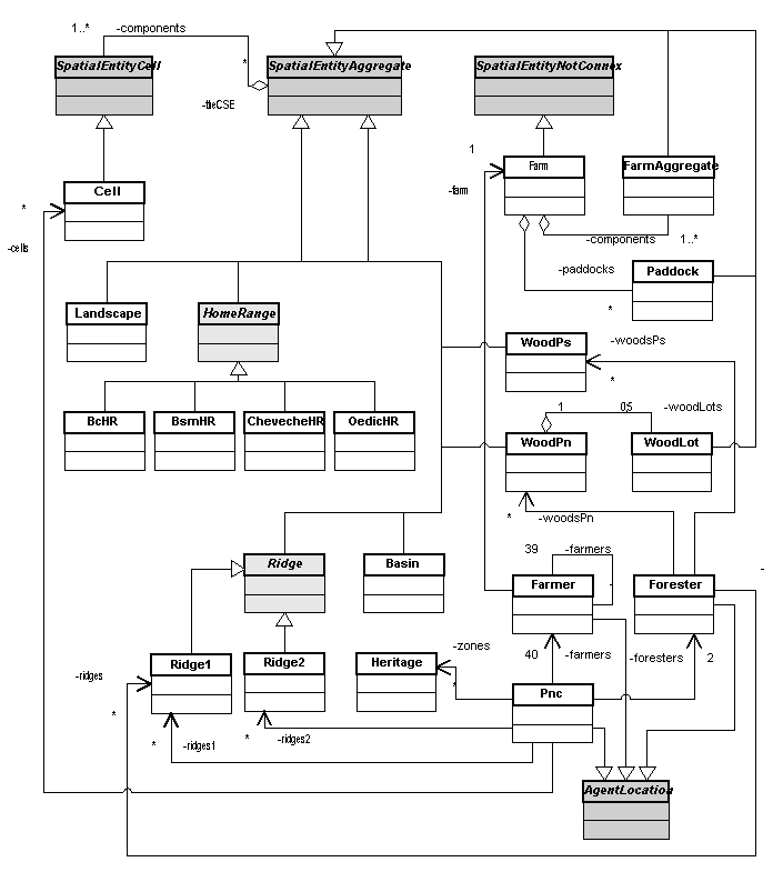
Figure 1. The UML class diagram of the model

3.2
Each rectangular box represents a class, which is an implementation of the corresponding entity of the model. Boxes in grey are generic Cormas classes. The Smalltalk program code of the model is available on request.

The land

3.3
The natural resources available were defined by topographical position, land use, land tenure status and heritage value (fauna, flora and landscape). The topography was accounted for by a map of ridges and dispersal catchments based on topographic maps. All the vegetation data came from ecological surveys carried out by the National Park (Parc National des Cévennes 1999). A land-use map describing vegetation forms according to the combination of vegetation layers (tree, shrub or grass) showed the vegetation structure. Woodlands were described more precisely through dominant species, age and canopy cover. Agricultural activities were spatially characterised by the land tenure of each farm, the location of the shed and the cultivated areas. The natural heritage value was assessed by a set of maps accounting for landscape units, the location of endangered plant species and the home range of the eight key species considered as the main conservation target of the National Park (Jestin and Rousselle 1997).

3.4
All these maps were combined and transformed into a 200m x 200m grid that was imported into the cellular automaton of the Cormas platform. This permitted to initialise the spatial grid of the model, represented by 5726 cells of 4 ha. The size of the cell was selected as a compromise between the time required to run a simulation and the relevant scale to account for the different ecological processes. A 200m x 200m unit was considered to be a minimum to model pine dynamics and to satisfactorily represent the home range of endangered butterflies and birds. And even if it was too big to account for the location of endangered plant species, it was tolerated for plant conservation under the principle of precaution.

The landscape dynamics

3.5
The landscape evolved as a result of the natural spread of conifers and the range management and timber harvesting regimes. An ecological model based on pine seed dispersal according to tree age, dominant wind and topography accounted for vegetation changes due to pine encroachment (Etienne 2001). The pine natural dispersal followed two overspreading processes: neighbourhood diffusion at the border of a mature stand, on the opposite side of the dominant wind; stratified diffusion in the immediate surroundings of isolated mature trees issued from "tail seedlings". The pine seedling establishment and development was partially controlled by grazing pressure according to the current practices of local farmers. A complete control of pine encroachment was only achieved by regular clearing of young pines before they reached reproductive maturity and according to the set of available and feasible techniques (chopping, burning, hand-cutting, etc). So, the intensity of the encroachment and the speed of the trend could be reduced by range or timber management decisions. And each cell had the ability to memorise any operation applied to the trees by any of the agents.

The sheep farmers

3.6
Thirty-seven sheep farmer agents were selected from a database providing information on their production system, grazing pressure on rangelands, environmental awareness, chain mower availability, attitude towards pine encroachment, year of retirement and most probable production system after retirement. Their grazing management strategy was modelled according to their production system (meat or milk, intensive or extensive), grazing pressure, distance to shed, and pine canopy cover on rangelands. Their behaviour when faced with pine encroachment was affected by the labour time available to cut pine trees, the amount of land tenure tax, the amount of timber harvested and the rangeland productivity. Figure 2 shows the sequence of actions coded into the model to simulate the behaviour of each farmer at each runtime (one year).

Figure 2
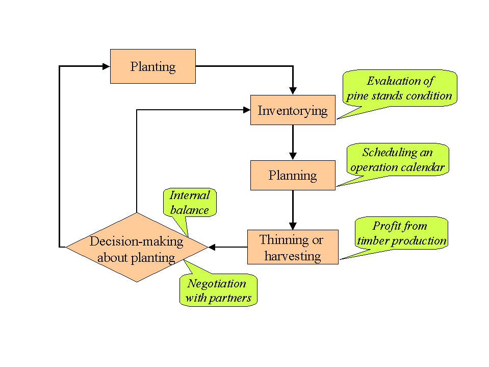
Figure 2. The farmers' activity diagram

3.7
The basic grazing pressure, defined according to real data, was adjusted year by year according to changes in rangeland productivity provoked by pine encroachment. Pine control was decided according to the available labour or possibility of getting financial support from other partners such as the National Park. Farmers' environmental awareness, their willingness to collaborate, time since the last collaboration and labour force to share were the four criteria taken into account during the negotiation process.

Figure 3
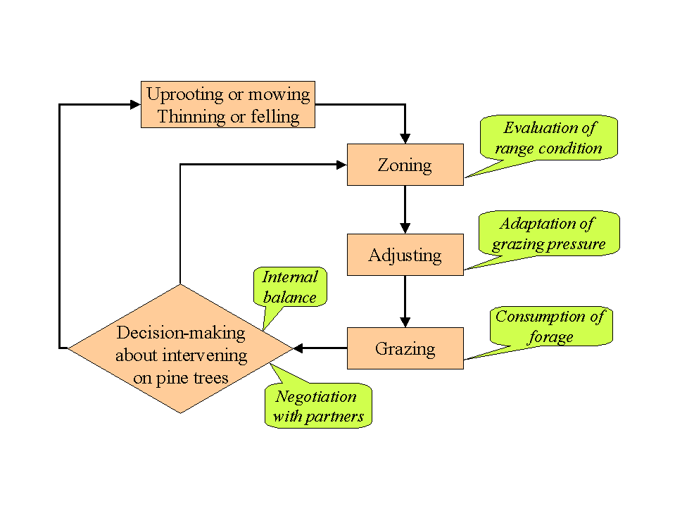
Figure 3. The foresters' activity diagram

The foresters

3.8
The model generated two types of foresters. One dealt with the management of afforestation and was charged with legal constraints to be respected (return of the debt, thinning schedule, re-afforestation after felling). The other dealt with native woodland exploitation and the organisation of supplies to the pulp industry.

3.9
In order to simulate forest management planning, the woodlands were divided into woodlots automatically generated by the model according to three rules: the trees must belong to the same age class, the cells must be contiguous and the patch must respect a minimum size.

3.10
The foresters defined their management strategy according to the dominant pine tree species, the age of the woodlot, the amount of timber harvested and the amount of working days available to manage pine trees. Figure 3 shows the sequence of actions coded into the model to simulate the behaviour of a forester at each runtime.

3.11
Heritage value of the dispersal catchment, ridge encroachment level, foresters' income-loss compensation and National Park cash availability were the four criteria used during the negotiation.

The conservationists

3.12
Land management by the National Park rangers was directed to pine destruction according to a land valuation based on flora and fauna heritage value and the maintenance of open landscapes. The rangers were able to get financial support for the control of pine encroachment but they were designed to spend this money in two different ways. The first was to select the sectors of the territory where strategic operations against pine encroachment could be developed; in this case they decided to clear first cells with high heritage value or ridges hanging over catchments with bare landscapes. The other was to select farmers whose environmental awareness would allow them to collaborate with conservationists through cost-shared actions on their farms. In this case, the conservationists decided to clear first all the invaded cells of the selected farms. Figure 4 shows the sequence of actions coded into the model to simulate the behaviour of the conservationists at each runtime.

Figure 3
Figure 4. The conservationists' diagram

* The Step-by-Step Approach

4.1
The involvement of the stakeholders throughout the modelling process was based on four concepts: 1) the opinion, the specific way in which each stakeholder perceives his resources and identifies the entities to manage; 2) the viewpoint, a spatial representation of an opinion; 3) indicators, a set of markers selected by the stakeholders to monitor the dynamics of their system; and 4) scenarios, prospective management rules to tackle the pine encroachment problem.

4.2
The interaction between the model and the stakeholders moved progressively from local individual aspects to global collective processes. It began exclusively with the specific parts of the model accounting for the practices of a specific stakeholder through individual enquiries (the National Park scientist who specialised in birds, a representative of milk ewe farmers, etc). The following meetings gathered several agents of the same category (conservationists, foresters) in order to get a common opinion if not agreement on the current state of the model. To build up the collective scenarios, meetings with the three categories of agents were organised both to assimilate the functioning of the model and to share representations among stakeholders. This part of the approach was reached in two ways: role-playing games to project the stakeholders in the future and force them to react to the ongoing processes and dynamics; shared meetings organised by the local district community to stimulate discussion around the pine encroachment problem.

4.3
As the Cormas platform allows for the modelling of land dynamics by means of a cellular automaton, a basic viewpoint was designed in order to represent the physiognomic characteristics of the vegetation according to the modeller's point of view. As it had to be easily understood by any stakeholder or manager, it was based on a very simple rule: the primary colours were attributed to the basic plant types: trees were blue, shrubs red and grasses yellow. When different layers were superimposed, the corresponding colours were mixed. This "vegetation forms" viewpoint (see figure 5) was considered to be the basic key to be shared by all the participants to the modelling process. In a way, the modeller imposed it as the common viewpoint to read and understand landscape dynamics.

Figure 5
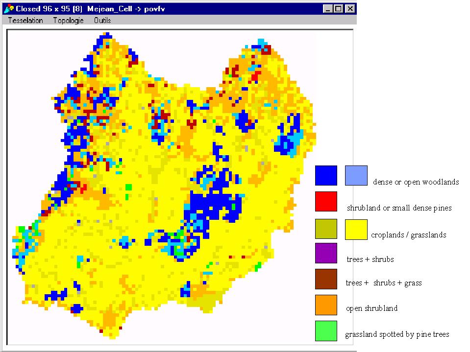
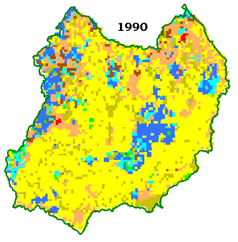
Figure 5. The spatial grid of the model from the "vegetation forms" viewpoint

4.4
Then, the first stage of the simulation approach was to validate the way the ecological process and the stakeholders' behaviour were integrated into the MAS. For this, a scenario corresponding to the current situation was devised and discussed with each type of agent. According to their own experience or to what they could observe in the field, the majority of the stakeholders agreed with the simulated trends and the way pine encroachment was translated into the model. But a set of individual opinions arose from these discussions, showing how specific to each stakeholder and specialised perception of the resources and the criteria to define management entities were.

4.5
In a second stage, the indicators mentioned by the main stakeholders (foresters, farmers and rangers) as essential to them to plan their activities and understand the dynamics of their resources were listed. Accordingly, a set of viewpoints was designed with the stakeholders and they were individually used to validate the model. After running the simulation, the most common reaction was to propose minor modifications to some indicators along with alternative individual scenarios to improve the management of resources.

4.6
The third stage consisted in adapting the MAS to these scenarios, by creating new spatial entities according to specific rules of aggregation (Etienne and Le Page 2002) and by coding new behaviours and new ways to react to environmental changes. A new set of viewpoints was designed to make it possible to assess easily the impact of these basic management strategies on the main productive (sheep stocking rate, timber growth) and environmental (endangered species, landscape value) stakes on any spatial entity considered as relevant by any stakeholder.

4.7
The goal of the following stage was to view and confront collectively the different scenarios through each of the available viewpoints. It was then that the need to agree to a compromise was raised and this led to new scenarios based on a more collective management of pine encroachment.

4.8
In the last stage, the results of these alternative scenarios were collectively evaluated, which led to the selection of a set of feasible scenarios according to the current actors' perceptions and practices and to suggestions for alternative sylvopastoral management based on innovative practices.

4.9
Along this step-by-step approach, eight scenarios have been designed. They are labelled with integer numbers ranging from 1 to 8. The main objectives, the key markers and the stakeholders involved in the definition of the scenarios are listed in table 1.


Table 1: List and characteristics of the 8 simulation scenarios
ScenarioParties* Main objectiveKey markers used by stakeholders
1FBack to woodlandsForest stands, sylviculture
2SPreserve current productionStocking rate
3CPreserve current habitatsFlora, fauna and landscape heritage
4CImmediate return to grasslandsGrassland area
5F + CControl pine seed sourceRidges, natural heritage
6C + SLong-term environmental agricultureWork effort, natural heritage
7S + F + CSustainable timber and grass productionTimber production, stocking rate, natural heritage, working effort
8S + F + CProgressive return to grasslandsTimber production, stocking rate, natural heritage, working effort
* F = foresters; C = conservationists; S = sheep farmers

4.10
Some indications about the implementation of the scenarios (sequence of basic processes to be performed) are given in table 2.

Table 2
Table 2. Sequences of basic processes for the 8 simulation scenarios. Each line represents a basic operation, each column represents a scenario (as described in table 1). When the intersection between a line and a column appears in grey, it means that the corresponding basic operation is activated for the corresponding scenario.

* The Individual Scenarios

Foresters (scenario 1)

5.1
Foresters considered that pine encroachment is a natural process moving early succession stages (i.e. native grasslands) towards late succession stages (i.e. native or sub-spontaneous forests). They also pointed out that the intensity of the currently observed process demonstrated that sheep farmers were unable to manage correctly their rangelands. So they proposed a scenario called "let nature work" in which landscape dynamics depend only on natural succession according to the location of the current tree seed bearers. They hypothesised that grazing management was too extensive to control pine seedlings on rangelands and decided that any new land unit colonised by pines more than 20 years old would go under their management rules. They only accepted to respect the agreement they had made with the conservationists to stop undertaking new afforestation.

Sheep farmers (scenario 2)

5.2
Farmers were ready to control pine encroachment only in places where it competed with farm production but they stressed the shortage of labour for such operations. The places to clear were determined according to the current land tenure pattern and requirements of the sheep production system. They hypothesised that pine encroachment was totally controlled in cultivated areas and partly reduced in grazed areas according to current grazing practices. They did not schedule any intervention on their planted pine stands but they supposed the other forests to be managed as usually by means of basic sylviculture following the standards proposed by the forest law and the regulations imposed by the National Forest Fund programme. No proposal was made for adapting the grazing calendar to increase grazing pressure on the threatened paddocks, and cooperation with the National Park agents was never mentioned.

Conservationists (scenarios 3 and 4)

5.3
The majority of the conservationists considered that they had mainly to prevent the areas with major heritage value to be invaded by pine trees. So they proposed to finance the eradication of pine trees already established in areas with high biodiversity or high habitat interest and to support the control by regular mechanical interventions of the establishment of new pines in these areas.

5.4
Some of them even argued that the natural spread of conifers had to be stopped on all the territory because this was one of the two remaining pseudo-steppe landscapes of Western Europe and it had to be maintained at any cost. So they asked for testing a scenario called "recreate the steppe" (scenario 4) -

in which Scots pine would stand and Austrian black pine afforestation would be eliminated and spontaneously replaced by native grasslands newly devoted to grazing. They assumed that the current ecological process of pine encroachment was too strong and widely distributed to be controlled without a drastic decision such as the complete eradication of adult pine stands.

* The Viewpoints

6.1
The MAS demonstrated that it was a good support to help the stakeholders determine the range of possible strategies through which they might adapt to a process with which they had not yet been confronted. Two aspects were particularly effective: sharing dynamic processes and comparing contrasting scenarios.

The modeller's viewpoint

6.2
On the first aspect, specific viewpoints were required to make it possible for the modeller to explain and share scientific issues arising on different temporal and spatial scales. A particular effort was made to design viewpoints that helped the participants to exchange their views on pine encroachment. A clear distinction was made between the physiognomic aspect of an encroached land (pines can be easily seen far away from the cell) and the real presence of pine trees (the cell is already invaded by pine seedlings).

6.3
Indeed, the "vegetation forms" viewpoint gives a good representation of what is seen by the stakeholders because it gives evidence of the presence of trees only when they modify consistently the structure of a piece of land.

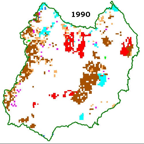
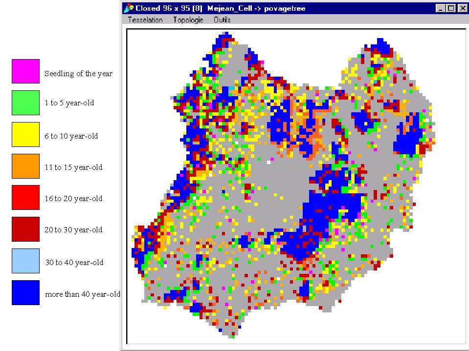
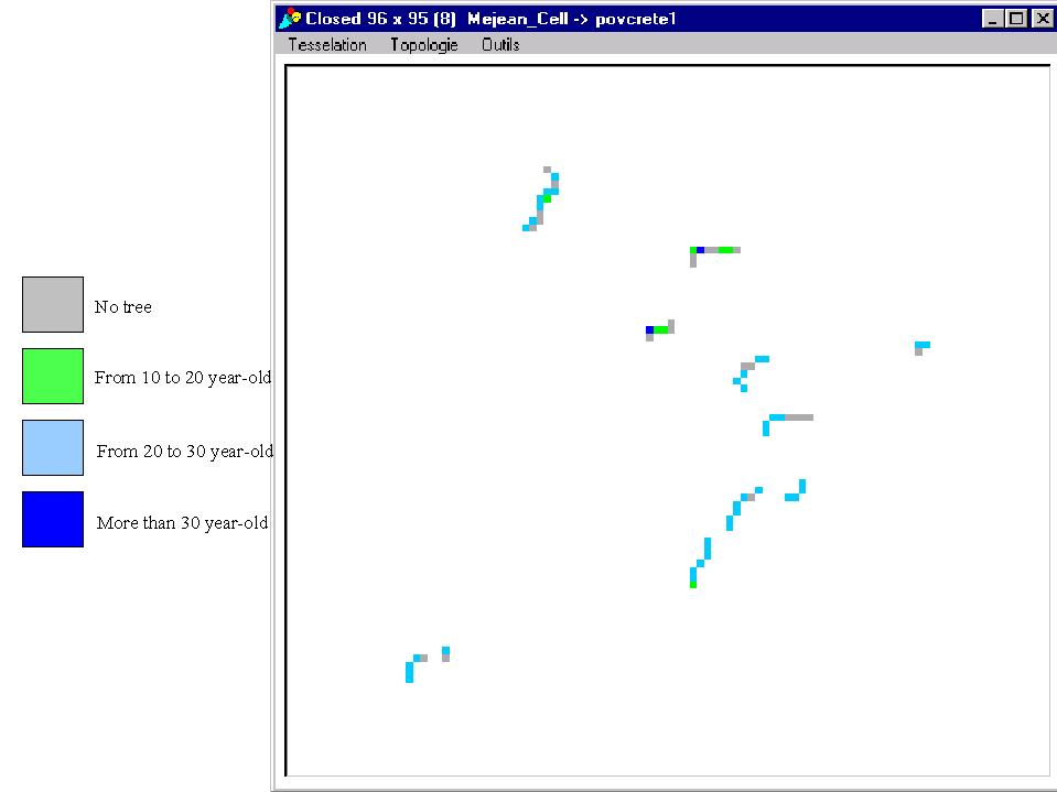
But much time had passed since the beginning of the encroachment process until the moment trees were visible to farmers, park rangers or foresters. Besides, it was important for the modeller to be able to show clearly to the stakeholders the progress of the pine overspread. The best criterion to express the ongoing process was to visualise the location of the trees according to age. A colour represented each important succession stage (seed establishment, seedling development, savannah-like stand, and forest stand). Shades accounted for gradients during the same stage. Each time a cell was invaded by new pine seeds it became pink, then, while pine trees were growing without being easily visible, the colour of the cell turned from green to yellow. When pine trees became part of the landscape (ages ranging from 10 to 30 years), the cell colour turned into an increasingly darker shade of red. Over 30 years of age, pine trees were supposed to belong to manageable forest stands and the cell turned into shades of blue (figure 6).

Figure 6
Figure 6. The spatial grid of the model from the modeller's viewpoint, based on the ages of the trees

The forester's viewpoint

6.4
But the "vegetation forms" viewpoint provided too detailed information on tree age and was not precise enough on tree species and tree density to help foresters monitor the dynamics of their resources. They asked for a formula locating clearly all the pine woodlands ready to be managed. As the time of intervention and size of management units differed according to dominant pine species and tree density, a two-parameter typology was proposed.

6.5
Colours were used to express the dominant tree species and the dominant production objective: blue for Scots pine (Pinus sylvestris) exclusively devoted to firewood or pulp production, and green for Austrian black pine (Pinus nigra) established for timber production but providing some thinning by-products to the pulp industry. The shade informed on tree density (figure 7).

Figure 7
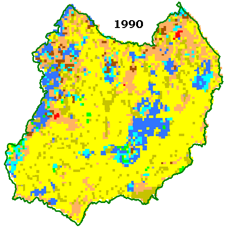
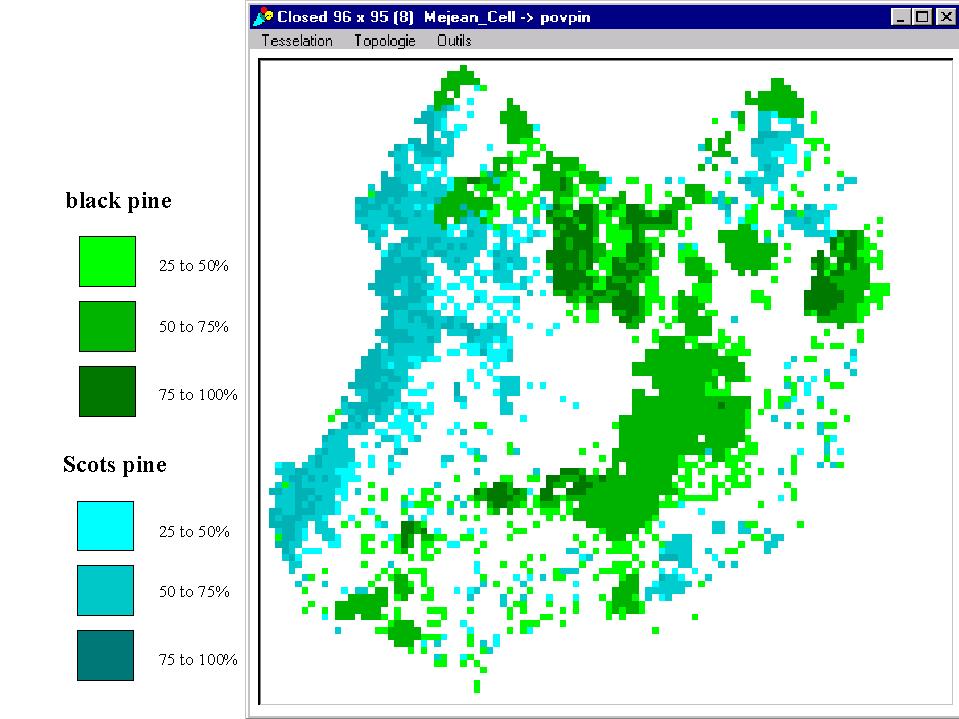
Figure 7. The spatial grid of the model from the forester's viewpoint, based on the species and the density of the trees

6.6
This viewpoint was generally compared with the distribution of pine stands according to age classes in order to get a good idea of the productivity level of the stands. It made it possible for the foresters to define management units called "woodlots" that make sense according to the thinning and felling programme they are used to carry out and according to the timber volume requirements imposed by the logger or the pulp factory.

The conservationist's viewpoint

6.7
Conservationists had a completely different take on the Méjan land. They asked both for a view on patches defined by a certain level of heritage value and for a way to monitor the maintenance of open landscapes. The first opinion was based on an index summing up flora, fauna and landscape stakes, and was supposed to allow for rapid detection of patches large enough to warrant sustainable conservation of valuable habitats (Etienne and Le Page 2002). This viewpoint required first finding a consensus among National Park scientists on which species constituted the core value of the Natural Heritage of the Park (rare, endangered, emblematic species) and on their relative conservation priority. Then, the home range or spatial distribution of each species had to be defined precisely according to available scientific knowledge and inventory data (Jestin and Rousselle 1997; Parc National des Cévennes 1999).

6.8
The second opinion was based on an index of landscape quality calculated on specific spatial entities called landscape units which corresponded to portions of land with a specific scenic view (figure 8).

Figure 8
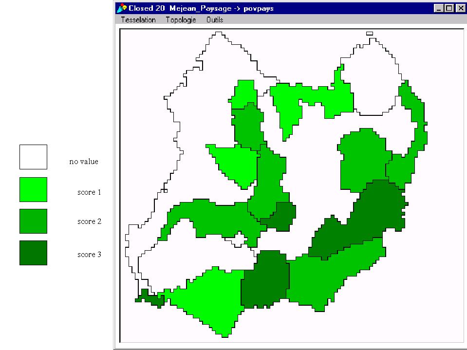
Figure 8. The landscape units of the spatial grid of the model, as defined by the conservationists

6.9
This viewpoint required finding a consensus among the National Park rangers and scientists on which were the most typical landscape units, where their limits were and how to rank them.

6.10
As the conservationists were looking for a synthetic heritage index, a long discussion and several tests were needed to assess the sensitivity of the previously selected markers and to weigh the landscape factor compared with the fauna and flora factors. The final agreement gave no hierarchy among the selected plant and animal species: one point for each core species; the value of each cell of the grid calculated by adding up the points (minimum value 0, maximum value 10); and a landscape index ranging from 0 to 3. The sum of both scores gave a global heritage index that was used to build the heritage viewpoint with a gradient among warm colours from yellow (low index) to dark red (high index). Cells with exceptional value (over 8 points) were coloured pink (figure 9).

Figure 9
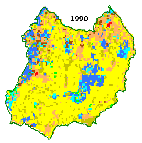
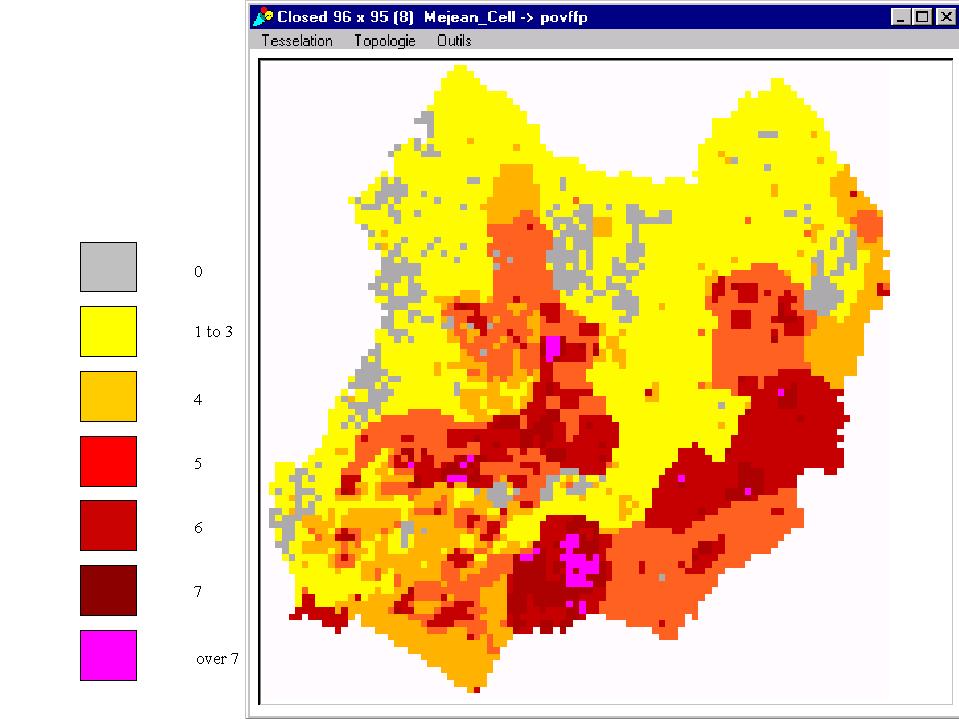
Figure 9. The spatial grid of the model from the conservationist's viewpoint, based on a heritage index

* The Collective Scenarios

7.1
Two main types of scenarios were elaborated during the collective sessions. One fitted with an agreement on the pressing need to conserve most of the endangered habitats and thus to establish a global strategy of pine encroachment control. The other was based on an agreement to promote sustainable development of agricultural and forestry practices aiming at a progressive decrease of the area covered by pine woodlands.

Agreement on the conservation target (scenarios 5 and 6)

7.2
Two options were considered to reach the conservation target. Scenario 5 was initiated by a potential agreement between conservationists and foresters to define and give priority to operating on strategic ridges. These ridges were defined as key management entities where the felling of adult trees would stop pine seeds overspreading on catchments of high heritage value over a long period. The originality of the approach has to be underlined as the concept of "strategic ridge" defined a spatial entity specially designed to tackle an environmental problem (Bellon et al 2002). Even if this scenario required a delicate compromise between foresters and conservationists, it was tested to see how many farmers and forest private owners would be willing to share the deal - farmers, by maintaining sustained grazing pressure on the rangelands of the selected catchments, and forest owners, by accepting to stop producing timber on part of their land. To easily monitor the number of cells to be treated a ridge viewpoint was designed. Each ridge located on the eastern edge of a pine afforestation plot was painted according to the age of the dominant tree: green for under-20-year-old pine trees, light blue for 20- to 30-year-old pine trees, dark blue for over-30-year-old pine trees (figure 10).

Figure 10
Figure 10. The spatial grid of the model from a viewpoint designed to visualise the ridges located on the eastern edge of pine afforestations

7.3

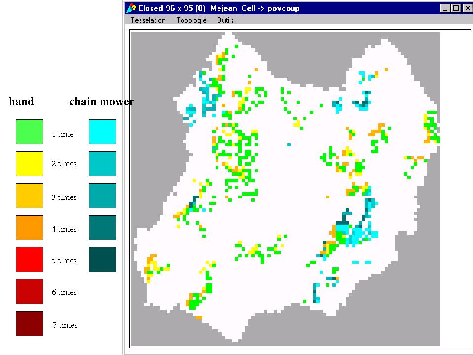
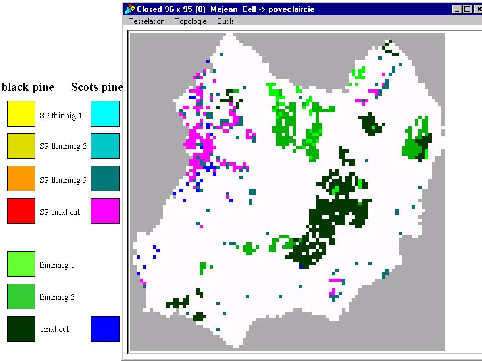
Scenario 6 originated from the wish of National Park rangers to support farmers with environmental awareness and ecological practices to follow up on the agro-environmental measures taken by the European Union. Once farmers had been rated according to the quality of their practices in terms of ecological impact, the conservationists shared with the best-ranked farmers the work or cost of eradication of the pines. Both sets of people asked for a viewpoint on the work effort for pine cutting or mowing, to have an idea of the intensity and frequency of work they would have to put in the field. Farmers or rangers could control pine encroachment by either chain mowing (blue shades) or hand clearing (red shades). The darker the shade, the higher the frequency of intervention for getting rid of the pine trees. The first cuts were painted green in order to figure out easily, at the end of the simulation, the stands initially dominated by pine trees and exploited for timber (figure 11).

Figure 11
Figure 11. The spatial grid of the model from a viewpoint related to the intensity and frequency of work effort for pine cutting or mowing

Agreement on sustainable development (scenarios 7 and 8)

7.4
The representatives of the farmers and the forest owners preferred to test long-term scenarios based on more pragmatic and realistic operations. The long-term goal remained to restore or at least to extend partly the steppe landscape based on "naked" native grasslands. But the means proposed was a progressive transformation of agricultural and forestry practices through the development of sylvopastoral management plans.

7.5
Two options were proposed. The foresters argued for a sylvopastoral management focused on timber production whereas the "Chambre d'agriculture" supported sylvopastoral management focused on forage production. Both options led to the restoration of native pastures after the final exploitation of sylvopastoral plots.

Scenario 7 intensified the management of pine woodlands through a strong thinning of stands over 40 years old on 20-ha plots in order to set up rapidly rational grazing and to produce enough timber to make the venture worthwhile for loggers. It required the approval of the owner when the land did not belong to the farmers and it made it possible to anticipate the final harvest when the trees were about 60 years old.

7.6

Scenario 8 was restricted to pine woodlands located in owned or rented farms. It consisted in operating 2 or 3 rounds of thinning on encroached cells as early as the pines were over 20 years old. Thinning was scheduled every ten years until trees were 50 years old in order to maintain a relatively thin tree canopy that warranted the presence of a dense layer of grass, thus avoiding the woodland tax[1]. As farmers pointed out that this type of operation was time-consuming and provided no financial income during the first thinning period they decided to practise thinning only when they began to suffer from a lack of forage on native pastures.

7.7
In order to follow the impact of the management strategies underlying each scenario, practical viewpoints were designed. One monitored the successive stages of woodlot management. This made it possible to view the basic sylviculture when applied to black pine afforestation (light green for the first thinning, green for the second thinning, dark green for the final cut) and to identify the exploitation of Scots pine woodland for firewood (dark-blue cells). And it put particular emphasis on sylvopastoral management of both pine species: from yellow to orange for black pine and shades of blue for Scots pine. Final cuts were painted with vivid colours (red for black pine and pink for Scots pine) to be easily located (figure 12).

Figure 12
Figure 12. The spatial grid of the model from a viewpoint related to the sylviculture, with emphasis on the sylvopastoral management

Results

7.8
On the Causse Méjan scale, the trend followed by the surface covered by dense woodlands (figure 13) was an ineluctable increase of 1000 ha during the first 30 years of simulation (period 1990-2020).

Figure 13
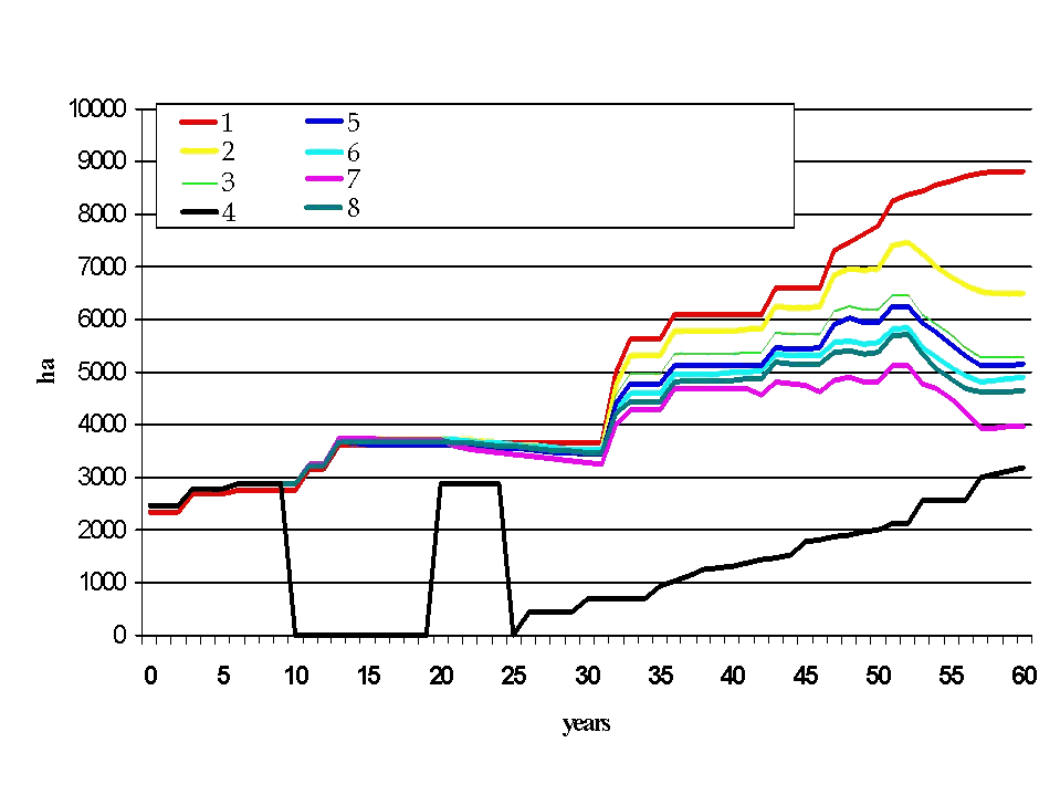
Figure 13. Evolution of the surface covered by dense woodlands for the 8 scenarios

7.9
After that, forest management began to have a clear impact on landscape structure and the collective scenarios were much more effective than the individual ones for any of the indicators used. Among these scenarios, the development of sylvopastoral plots for timber appeared to be a promising way to reverse, with a mid-term perspective, the current trend of pine encroachment and landscape closing.

7.10
At farm level, the results were more diverse, because the farms were not similarly concerned by the encroachment process and by the actions of pine control. The first factor that was significantly discriminative was the location of the farm according to wind direction and distance from a mature pine stand. The second factor was strongly related to the type of agreement simulated by the model. For instance, the association of the National Park and farmers with good environmental awareness made it possible to maintain rangeland productivity on 30 percent of the farms. But it was not effective enough to sustain the current production system of the 10 percent of the farms that exceeded the maximum potential of their rangelands (figure 14).

Figure 14
Figure 14

* Conclusion

8.1
The construction of contrasting viewpoints was essential to represent the way the multiple agents perceived the natural resources and the main dynamic processes. The utilisation of these viewpoints during the simulation process made it possible to inform thoroughly the main stakeholders of the issues that divided them and of their common dependence upon a solution to the pine encroachment problem. The elaboration of this set of perceptions through a step-by-step approach helped the participants to understand that their views were all legitimate but also subjective and partial. The opportunity to use this set to build up scenarios and to assess their impact on the natural resources made the discussion on the acceptability of possible trends much easier.

8.2
The step-by-step approach encouraged the participants to face collectively the environmental issue of pine encroachment and to plan cooperative actions in coming years. This improvement of the decision-making process made it now possible to move from a set of isolated management plans to the collective planning of a concerted local development plan by the National Park, the Forest Service and the Chambre d'agriculture.

8.3
Agent-based models dealing with the management of national parks have been applied to simulate the recreational use of wild lands (Gimblett et al 2002). Such approaches are mainly oriented towards natural resource managers, by providing them with a way to explore dynamic recreation behaviours before expensive management plans are implemented. Simulation technology may also promote greater public understanding of management decisions. Nowadays, decentralisation processes are emphasising the concept of "community-based natural resource management". Agent-based models have proved to be useful tools to involve stakeholders in a collective design of management plans (Bousquet et al 2002). Beyond the classical use of modelling as a decision support to control a system, agent-based models are also powerful supports to adaptive learning processes.


* Acknowledgements

The authors wish to thank all the staff of the Scientific Service of the National Park of Cévennes and of the Forest Service and Chambre d'agriculture of Lozère for their kind collaboration.


* Notes

1According to the Forest Law, a field encroached by trees for more than 20 years gets the land tenure status of forest and a National Forest Fund regulation stipulates that a pine plantation is exempt from the land tax for 30 years.


* References

BELLON S, ETIENNE M, LÉCRIVAIN E and NAVARRETE M (2002): "Activités agricoles, territoires et questions d'environnement : Quelles entités d'action ?" CR Académie d'Agriculture, in press.

BOUSQUET F, BAKAM I, PROTON H and LE PAGE C (1998): "Cormas: Common-Pool Resources and Multi-Agent Systems". Lecture Notes in Artificial Intelligence, 1416, pp. 826-837.

BOUSQUET F, BARETEAU O, D'AQUINO P, ETIENNE M, BOISSAU S, AUBERT S, LE PAGE C, BABIN D and CASTELA JC (2002): "Multi-agent systems and role games: an approach for ecosystem co-management". In Janssen M (ed.), Complexity and ecosystem management: the theory and practice of multi-agent approaches,Elgar Publishers, Northampton, England, pp. 248-285.

COSTANZA R and RUTH M (1998): "Using dynamic modeling to scope environmental problems and build consensus". Environmental Management, 22, pp. 183-195.

ETIENNE M (2001): "Pine trees - invaders or forerunners in Mediterranean-type ecosystems: a controversial point of view". Journal of Mediterranean Ecology, 2(3-4), pp. 221-232.

ETIENNE, M., and LE PAGE C (2002): "Modelling contrasted management behaviours of stakeholders facing a pine encroachment process: an agent-based simulation approach". Proceedings International Environmental Modelling and Software Society Conference, Lugano, Switzerland, June 2002, pp. 208-213.

GIMBLETT H, ROBERTS C, DANIEL T, RATLIFF M, MEITNER M, CHERRY S, STALLMAN D, BOGLE R, ALLRED R, KILBOURNE D and BIERI J (2002): "An intelligent agent-based model for simulating and evaluating river trip scenarios along the Colorado River in Grand Canyon National Park". In: Gimblett H (ed.), Integrating geographic information systems and agent-based modelling techniques for simulating social and ecological processes. Oxford University Press, pp. 245-275.

HOLLING C (1978): Adaptive environmental assessment and management, John Wiley, London.

JESTIN P and ROUSELLE P (1997): Catalogue de la flore du Parc National des Cévennes.Parc National des Cévennes, Florac, France.

LEPART J, MARTY P and ROUSSET O (2000): " Les conceptions normatives du paysage. Le cas des Grands Causses ". Natures, Sciences et Sociétés, 8(4), pp. 16-25.

O'ROURKE E (1999): "The Causse Méjan: changing relationships between agriculture, environment and society within a French National Park". Landscape Research, 24(2), pp. 141-165.

OSTY P-L, LARDON S, LHUILLIER C (1994): " Systèmes techniques et gestion de l'espace : quelle qualité de l'organisation spatiale ? Les élevages ovins du Causse Méjan ". Études et Recherches sur les Systèmes Agraires et le Développement, 28, pp.211-218.

PARC NATIONAL DES CÉVENNES(1999): Atlas du Parc National des Cévennes. ATEN, Montpellier, France.

----

ButtonReturn to Contents of this issue

© Copyright Journal of Artificial Societies and Social Simulation, [2003]