
 Abstract
- The study refers to the interactions between socio-economic and natural dynamics in an island biosphere reserve by using companion modelling. This approach provides scientific results and involves interdisciplinarity. In the second phase of the study, we transferred knowledge by adapting the main research output, a role-playing game, to young people. Our goal was to introduce interactions between social and ecological systems, coastal dynamics and integrated management. Adapting the game required close collaboration between the scientists and educators in order to transform both its substance and form and to run it with an easy-to-handle ergonomic platform.
- Keywords:
- Children Education, Multi-Agent Environment, Role-Playing Game
Context
- 1.1
- Interdisciplinary research conducted in the environmental field is often confronted with the complexity of functional processes, the absence of appropriate methods and the dissipation of skills and data in an area of study which is both vast and tackled by many different institutions. In addition, research that aims to contribute to sustainable development not only involves a systemic and interdisciplinary approach, but also requires the empowerment of civil society stakeholders in acquiring knowledge and learning to speak the same language. Indeed, the collective action advocated by this concept is not limited to the scientific realm alone. It also involves finding synergies with local management policies and users, and implies helping them in their procedure by designing methods and tools and making them available. The objective is to promote the enhancement of goods and services of a territory to maintain local populations and ensure their well-being. The methodology must therefore be part of an interactive process during which stakeholders with diverging interests progressively construct a shared representation of reality, give it meaning and set goals for themselves. For effective deliberation, these stakeholders must be able to access information and produce knowledge. Public awareness-raising and education are also sought, for individuals to become aware of their own role in the ambitious political project that sustainable development represents (Brodhag 2004).
- 1.2
- In the first phase of our study, we examined the interactions between socio-economic and natural dynamics in Ushant Island (West Brittany, France)[1] by using companion modelling (ComMod 2005;D'Aquino et al 2001). Ushant Island is part of a regional natural park and was designated part of the Mer d'Iroise Biosphere Reserve in 1988. The international biosphere reserves network (UNESCO MAB program) has three main objectives: biodiversity conservation, sustainable development, and environmental education, training and involvment of the local population (Batisse 1990).
- 1.3
- This small island (1541 ha), located off the western coast of France, has been experiencing landuse and landcover changes (Gourmelon et al 2001) for several years. Major land use changes resulted in fallow land encroachment and its consequences on landscape, traditional activities and biodiversity.
- 1.4
- Within the companion modelling approach, a conceptual model of the "Ushant Island system" was constructed, thereby providing the basis for the development of a prototype using the CORMAS multi-agent platform (CIRAD) (Bousquet and Le Page 2004; Bousquet et al 1998; Gourmelon et al 2008; Levrel et al 2009; Rouan et al 2010). It was used as the basis of several scenarios to explore trends in the environment and biodiversity, according to various socio-economic options (e.g. decline or increase of grazing, maintenance of coastal sward, etc.) (Kerbiriou et al 2009; Gourmelon et al 2008). This concrete application together with companion modelling enhanced interdisciplinarity (Wiesmann et al 2008). Concurrently, a role-playing game (RPG) run by the platform was initiated to improve the model and raise the stakeholders' awareness of the dynamics underway[2] (Charles et al 2008; Chlous-Ducharme et al 2008). In the second phase, the discussion turned to transferring knowledge to the civil society[3] by adapting research outputs to two operational contexts, in order to promote their mastering and adoption by two types of publics:
- multi-agent simulation and RPG as management support to a territory submitted to constraints (designed for management purposes),
- RPG to help raise awareness and help young people learn about sustainable development issues (designed for educational purposes).
- 1.5
- This paper refers to the second aspect, devoted to transferring a RPG created in a co-modelling experiment in a multi-agent environment to an audience of schoolchildren.
 Objectives
- 2.1
- Sustainable development education involves making links between disciplines and aims at providing students with an understanding of their surroundings and developing their abilities to get involved (Vergnolle Mainar 2008; 2009). Yet despite definite awareness[4] which occurred some thirty years ago, the French high-school system still favours disciplinary mechanisms with no actual contribution to a cross-disciplinary object (Tutiaux-Guillon 2009). In this context, the goal set by other organisations such as local authorities, scientific and technological culture centres, programmes including that of the UNESCO "Man and the Biosphere" as well as environmental protection groups is environmental education for youth, which involves knowledge transmission methods differing from those traditionally implemented by the Ministry of Education.
- 2.2
- Among these transmission methods, a play-based approach would raise young people's awareness of the environmental processes taking place on several temporal and spatial scales and develop their ability to implement the sustainable development concept, in the same way Minassian and Rufat (2008) showed that certain video games had educational relevance in teaching geography. Since this is related to deliberations between diverse stakeholders, the game's objective is not just to promote the learning required for a dialogue that would not exclude those who most lack either knowledge or skills, but that would also allow new standards and values to be acquired. In this context, the game, for which Ushant Island was taken as a model, should be adapted to a broader geographic framework to raise public awareness of environmental issues and deliberation processes. Therefore, the proposed method must be flexible enough to be transposed to any coastal area; since the final objective is to ensure a transfer of tools which can be re-utilised in the educational realm without scientists and regardless of the initial application site to raise youth's awareness of sustainable development.
The Educational Workshop "Between Land And Sea: Coasts"
-
Familiarisation to the RGP for the educational team
- 3.1
- The team in charge of this part of the study is the educational department of Océanopolis[5], its two relay advisers from the Ministry of Education (educational team) and three researchers (scientific team) involved since the beginning of the project. The first step for new participants (the educational team) is to become familiarised with the RPG and understand how it works. To this end, the whole team met several times to analyse the game proposed by the scientists, define how it could be incorporated into a broader educational project and provide any modifications required. After analysing a number of school curricula, it appeared that the game had educational relevance for high-school students in the fifth form (US 10 th grade) on several themes: the evolution of the environment considered as an area developed by human societies, the role of man and society in the development of these territories, the footprint of tourism and populations on coasts, the impact of human activities on coastal areas, the need for specific management and protection, the study of a relatively unpopulated coastal zone, the fragility of an ecosystem and interactions between humans and the Earth's outer layers.
- 3.2
- On this basis, it was decided that the RPG would be part of an educational workshop on the coastal area theme proposed by Océanopolis for fifth-form students.
How and why?
- 3.3
- The educational workshop is based on three work sessions which take place at Océanopolis under the supervision of an instructor: the RPG, the guided tour of Océanopolis' temperate pavilion and a "Summary outline" session. The study of a local case (Iroise Sea) provides an extension of the school curricula, while broadening their outlook. The issues could partly be tackled by finding information on the various exhibition displays in the temperate pavilion at Océanopolis. The summarising exercise can be provided as a sketch or outline, in compliance with the official guidelines of the Ministry of Education and with high-school final examinations (A-levels) in prospect. The content of this workshop ties in with:
- fifth-form geography courses ("coastalisation" of activities, study of a seafront, development of tourism and recreational activities, urban development in coastal areas, changing landscapes, protection schemes);
- curricula for civic, legal and social subjects in high school (citizenship classes [using role-playing games], decision-making, speaking to a group, collective action and debating);
- fifth-form life and earth sciences curriculum (teaching sustainable development, relationships between humans and animal species).
Adaptation of the RPG for the Educational Workshop "Between Land And Sea: Coasts"
- 4.1
- The RPG aims to improve schoolchildren's awareness and learning of sustainable development stakes. Originally developed for adults playing their own role and provided with knowledge about activities and the environment (Charles et al 2008; Chlous-Ducharme et al 2008), and towards a mediation goal, the RPG's adaptation to this new context required various modifications, mainly as regards the conceptual model, the game board and rules, and computer interface.
- 4.2
- The initial game uses the knowledge acquired in the research project and the possibilities presented by the CORMAS platform (D'Aquino et al 2002). The transfer of the prototype described in Rouan et al (2010) to a RPG involved simplification mainly regarding land, leading to abstract representation, and rules. Indeed, vegetation dynamics only were taken into consideration, as the game aimed at dealing with relationships between different human activities and environmental degradation, and correlatively, with the latter's impact on such activities.
- 4.3
- Each session, about two hours long, included three phases: game presentation (goals and rules), game play with about ten turns simulating twenty years, and game analysis by all protagonists.
The conceptual model
- 4.4
- In order to elaborate this new RPG an adapted conceptual model has been built (Fig. 1).
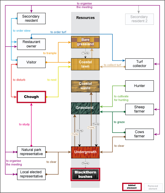
Figure 1. Conceptual model of the natural and social interaction in the new RPG - 4.5
- This model highlights the modifications that were required to adapt the RPG to meet its new target. A new class of vegetation has been added: the impassable scrub (blackthorn bushes). It was included in order to bring in a strong constraint as regards accessibility and visibility, and to generate potential collective decision-making. In the game, it is indeed impossible to clear this type of vegetation using the default means available to players.
- 4.6
- Eight roles (out of nine initially) were retained: local elected representative, natural park representative, cattle farmer, restaurant owner, president of the hunting society, turf collector, second-home owner and permanent resident (sheep farmer). In the previous configuration, two second-home owners were represented but due to the relative passivity of this role, only one was maintained.
- 4.7
- It is important to note that most of the roles involve several actions. For instance, the hunter, restaurant owner and the turf collector also keep sheep. The role of the visitor is played by the second-home owner who organises walks on the island.
- 4.8
- A protected bird species that nests in coastal cliffs was also included in the game in order to introduce the concepts of biodiversity and conservation. Two pairs present at the beginning of the game may breed, persist or disappear depending on the evolution of the environment and of the players' activities. The position of nests is set randomly at the game's initialisation. The park representative is the only one to be aware of this species' status and possibly location. Its protection may be the subject of a collective decision or may not arouse any specific interest.
The game board and rules
- 4.9
- The game board is similar to a draughtboard with 100 cells representing 5,000 m2 (Fig. 2). Each cell represents land including coastal sod, heathland, grassland, scrub and impassable scrub. A game board was specially created by an artist, taking account of the educational department's comments to make it more attractive for a young public: colours of board and squares, squares with holes for easier handling, and shape and appearance of the playing pieces. The content of the game cards has also been adapted (Fig. 2).
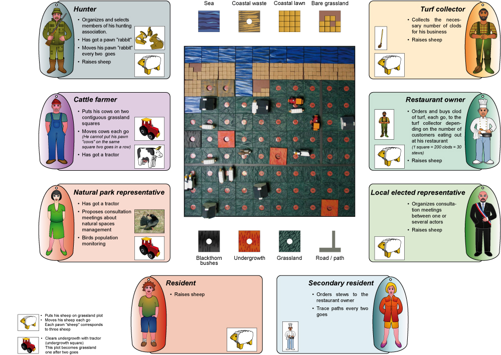
Figure 2. Presentation of the board, roles and actions - 4.10
- The game rules are structured as follows (Fig. 2).
- 4.11
- Gathered around a game board representing an area of land, eight players are given action cards (turf-stripping, mowing, clump ordering, etc.). The players' actions cause environmental evolution that may lead, for instance, to scrub encroachment on ungrazed plots, management of mowed plots, deterioration of the coastal area, etc. The computerised prototype is used at the end of each turn to determine the land changes induced by the players' actions. The scrub encroachment process on open land is voluntarily accelerated in order to create reactions, from the first turns, which may involve various individual or collective strategies to maintain (or not) an open area. Six to ten rounds can be played per session, simulating the evolution of the environment over a timeframe of 12 to 20 years.
Computer application interface
- 4.12
- A specific Graphical User Interface (GUI) was developed in collaboration with an IT consultant from Oxiane[6] in order to adapt it to the workshop and to make it easier to use for the facilitator. In the previous configuration, the prototype required three people to operate it: one acted as a game master, another transmitted the players' moves to a third person who was in charge of entering the data in a text file and running the model. Finally, the game board had to be updated with the results of the simulation.
- 4.13
- The challenge was to design the application in order to make it usable by the game master alone. Therefore, the Oxiane consultant had to take into account some constraints, i.e. simplifying the operations to be performed, checking the rules and making the interface more user-friendly. The system had to be robust, intuitive and simple to use. A peripheral device (graphic tablet) was opted for to allow the facilitator to remain mobile and always present for the players.
- 4.14
- Obviously, in order to make the application thoroughly "tablet-friendly", it was necessary to design it with a unique window, eliminating any sort of drop-down or contextual menu. Regarding the stylus' behaviour, it was decided to use a drag & drop metaphor, trying to make it as intuitive as possible.
- 4.15
- The application is based on Cormas, a powerful framework developed with the VisualWorks implementation of Smalltalk language (Howard 1995). This framework offers many interesting tools for programming multi-agent systems, including some components for visualising the space model, but it had rarely been designed for a role-playing game purpose (e.g. http://www.negowat.org/). In concrete terms, the standard Cormas tools used in the application consist of three windows. One is the main menu, one is opened to configure the simulation and the last is a visualisation of the space model.
- 4.16
- The first difficulty was to gather these three windows into one and to eliminate unnecessary functionalities in order to satisfy the ergonomic constraints of the game.
- 4.17
- Smalltalk language is particularly suitable for this kind of activity: components are programmed with the concepts of object and class and it is easy to directly reuse, modify or refine them. The main window was simply derived, its menus were removed, the initialisation step was automatically activated and finally the SpaceInterface and its SpaceView [7] were also derived and integrated in the right part of the main window (Fig. 3).
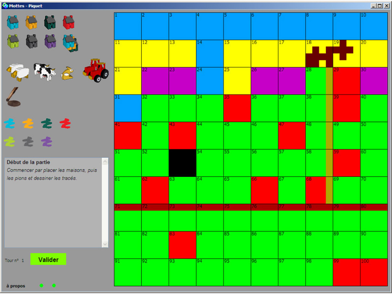
Figure 3. The interface - 4.18
- The second challenge was to actually make it user-friendly. It should be usable after a couple of hours of coaching. For this purpose, it was decided to use a metaphor of the real play on the board. Players take their playing pieces and drop them on the squares of their choice. They may take their pieces back and change their choices. The game master has to report their moves in the system (Fig. 4, 00:31, 00:49, 01:49).
Figure 4. Video showing 2 rounds being played (board/interface). - 4.19
- It should be natural for him to take icons on the left board, drag them and drop them on the appropriate squares. There are two tricks for this to be possible in the application. The first is a representation of the current task in something called InteractionMode. This class and its subclasses are used to precisely represent what we do with the stylus and what a click does. The SpaceModelIntegrable class, a redefinition of the Cormas class, has an 'InteractionMode' attribute including the current mode. It is similar to the 'current tool' concept in drawing applications such as MSPaint. The InteractionMode class supplies four simple elements, implemented as abstract methods:
- provides playing pieces that can be carried,
- provides an icon and its offset (used to display a representation of the current mode that follows the stylus),
- provides an action symbol used to easily test the current mode,
- provides an 'interact' method, called in response to a user click.
- 4.20
- The second trick is the use of a very powerful method called#follow:while:on:.
- 4.21
- This method is used to continually display an icon at the stylus' position until a stylus' click occurs, giving visual support for a drag & drop feeling. It is used in the#displayMode: method frequently called in the main window (further technical details are available in supplementary material).
- 4.22
- In addition, a number of operations were created to optimise the handling and supervise the sessions by automatically verifying the game rules. For example "cow playing-pieces must always be paired on 2 successive boxes and cannot be dropped on the same boxes as the previous round" or "only undergrowth can be cleared", etc.. The same visual features as the game board and colour codes of the players are used in the graphic interface of the application. After several uses, this interface allows the scientific facilitator to work alone and take on the game master's missions.
- 4.23
- To supplement the game, appropriate teaching tools and documents were also developed. A film called "The coast as a medium for a collective, multidisciplinary approach" was designed by the scientists working in collaboration with the Océanopolis relay advisers (Fig. 4, 00:01).
- 4.24
- It shows students the interdisciplinary work carried out by researchers, opens and closes the session. An educational document drawn up for students allows them to report on the different activities in the workshop and a file assists teachers in preparing their day at Océanopolis.
Evaluation
- 5.1
- In order to evaluate the running of the game by educators, the involvement of students and teachers and whether the workshop has met its aim of raising awareness of shoreline issues, 33 test sessions were set up. These sessions, involving 590 high school students, from 16 classes and diverse backgrounds, were monitored from January to June 2010.
Method
- 5.2
- In order to analyse the progress of sessions and their ability to meet the initial goals, the whole team (educational and scientific) developed a monitoring process. Each session takes place in the presence of an observer provided with an evaluation grid taking into account various criteria:
- Position and reaction of the teacher
- Students' reaction during the screening of the presentation film (level of comprehension, length)
- Students' understanding of rules and involvement in the game
- Individual and collective strategies used by the students during the game
- Actions implemented, possibilities offered by the game (sufficient? suitable?)
- Students' participation in the debriefing (questions asked, about what, by whom, what comments?)
- Running of the session by the educator, any difficulties encountered (rules, board, group …)
- 5.3
- In addition, a satisfaction survey was conducted among teachers on the workshop's organisation and content.
Results
- 5.4
- After 33 sessions, the team was gathered together through a workshop to analyse the observations made. Three observations made respectively by the teachers, Océanopolis educators and scientists were listed.
- 5.5
- Half of the teachers completed the survey by Océanopolis. Out of the 7 surveys completed, 5 reported the informant to be very satisfied with the workshop, its organisation and its content. Two of the teachers were satisfied, criticising two points: the length of the game (considered too long) and its aims, which were considered to be too vague.
- 5.6
- The unanimous view of the 4 Océanopolis educators involved in the 33 sessions was as follows. While familiarisation with the game and the handling of the board are not considered problematic, the educators experienced difficulties in introducing and concluding (debriefing) the session. The game's success with students varies according to classes. Certain sessions are very lively, with the students getting very involved in the game, while others are more passive. Teachers' participation is just as variable. Some are keen to join in, others are absent.
- 5.7
- During these test sessions, the scientists observed both the students and educators. The goal was to identify how players/high school students integrate knowledge specific to environmental management, natural and socio-economic dynamics, as well as conservation issues. This also entails the analysis of the skills involved as regards the wording of a problem, codes for taking part in the discussion, the capacity to listen to others and comprehend differences, the development of "sensible" arguments. The students quickly understand the rules and, by the end of the session, have a critical approach to the game. Some complain of the inactivity of certain roles (the second-home owner for instance), the lack of money and the limited means to control scrub encroachment. In response to the question "what is the purpose of this game", asked during the debriefing, two types of answers emerge: it raises awareness of land management and it demonstrates the difficulties involved in cooperation. The complexity, the challenges and the dynamics of the shoreline are rarely mentioned.
- 5.8
- In terms of the workshop organisation, the students consider the film to be slightly too long and complicated, in particular the section describing the conceptual model. On the other hand, the introduction to the game is considered useful, as is its conclusion, which also links in with the debriefing. The scientists observed that the debriefing is often shortened, or even omitted, because the rounds of the game take too long. Furthermore, when it takes place, the educator has difficulty in running it.
Improvement of the RGP
- 5.9
- The analysis of this monitoring effort enabled the team to improve the running of the game, mainly so as to facilitate the leadership of the session by the educator. The improvements include the drawing up of specifications, the simplification of the introductory film and the preparation of a PowerPoint presentation for the debriefing. No alterations were made to the game itself or its rules.
- 5.10
- Specifications were drawn up for the educator by the team. They guide the educator through the different stages of the session, specify the aims and expected outcomes of the game, enabling them to face unforeseen situations and answer various technical questions.
- 5.11
- The film, considered to be too long and complicated, was shortened, to focus specifically on the geographical context (the shoreline and its current challenges) and the introduction to the game.
- 5.12
- Finally, a PowerPoint presentation provides a framework for the debriefing (Fig. 5) and helps to conclude the session.
Figure 5. The guide for the debriefing
Conclusion
- 6.1
- A multi-agent model devoted to interactions between social and natural dynamics on Ushant Island was used as the medium for a RPG adapted to the school curriculum of fifth-form classes on the theme of sustainable development and coastal areas (History-Geography, Life and Earth Sciences and Civics). Adapting it required close collaboration between the scientists behind the project, the educational department at Océanopolis and teachers.
- 6.2
- Transferring the game required transforming both its substance and form, running it with an easy-to-handle ergonomic platform, as well as support from scientists in presenting the approach to teachers and a film to introduce the game.
- 6.3
- In terms of methodological aims, the RPG allows students to play an active part in their learning process through hands-on experience, and to concretely set out the issues involved. Yet what is the real aptitude of this type of tool to raise awareness and facilitate the learning experience of young people with respect to the environment, forecasting issues, and integrated and participatory management? This question is difficult to answer as it begs the question of how to assess the efficiency of these participatory tools. Nevertheless, the likelihood is that without the involvement of the teachers, resulting in subsequent work in class on the notions conveyed by the game, its aptitude to raise awareness will only last as long as the session … It is simply yet another experimental element.
Acknowledgements
- We thank the reviewers for their comments on the previous versions of this article. We thank the team in particular F. Chlous-Ducharme, L. David and P. Nicol. The financial support of the Brittany Region, CNRS (French Scientific Research Center) and Oceanopolis is acknowledged.
Notes
-
1 The project "Organisation de l'accès aux ressources et biodiversité, application aux réserves de biosphère françaises" (IFB, 2003-2006) coordinated by M. Etienne (INRA).
2 Supported by the Fondation de France.
3 The Project "Modélisation multi-agents et jeu de rôles : des outils de médiation et d'apprentissage au service du développement durable" (MEDIA) supported by the Brittany Regional Council scheme, Appropriation sociale des Sciences, and the INEE-CNRS & Cémagref programme, Ingénierie écologique.
4 Circulars 2007-077, BO n°14, 2007; BO n°28, 2004 ; BO n°31, 1977.
5 Océanopolis is an ocean discovery park in Brest ( http://www.oceanopolis.com). It offers a programme of educational workshops and teaching days specially developed for school pupils according to their level, from nursery school to the final year of secondary school, with the support of the French national education authority.
6 Technological consultancy firm - http://www.oxiane.com/
7 Graphic components of the interface lodging the visualization space of the model (cellular automat).
References
-
BATISSE, M. (1990). Development and implementation of the biosphere reserve concept and its applicability to coastal regions. Environmental Management, 17, 111-116. [doi:10.1017/s0376892900031878]
BOUSQUET, F. and Le Page, C. (2004). Multi-agent simulations and ecosystem management: a review. Ecological Modelling, 176, 313-332. [doi:10.1016/j.ecolmodel.2004.01.011]
BOUSQUET, F., Bakam, I., Proton, H. and Le Page, C. (1998). Cormas: common-pool resources and multi-agent Systems. Computer System, 1416, 826-838. [doi:10.1007/3-540-64574-8_469]
BRODHAG, C. (2004). De l'éducation à l'environnement au développement durable. Colloque sur l'Education à l'Environnement vers un développement durable, Muséum d'histoire Naturelle, Paris, 14-15 April 2004.
CHARLES, M., Chlous-Ducharme, F., Faugère, E. and Wintz, M. (2008). Science et démocratie dans la gestion de la nature : des ethno-sociologues pris dans la modélisation d'accompagnement. VertigO, 8(2), http://vertigo.revues.org/index4999.html.
CHLOUS-DUCHARME, F., Gourmelon, F. and Rouan, M. (2008). Modélisation et jeu de rôles sur l'île d'Ouessant : questions de sociologie. Socio-logos, 3, http://socio-logos.revues.org/document2112.html
COMMOD, COLLECTIF (2005). La modélisation comme outil d'accompagnement. Natures, Sciences et Sociétés, 13, 165-168. [doi:10.1051/nss:2005023]
D'AQUINO, P., Etienne, M., Barreteau, O., Le Page, C. and Bousquet, F. (2001). Jeux de rôles et simulations multi-agents : un usage combiné pour une modélisation d'accompagnement des processus de décision sur la gestion des ressources naturelles. In Trebuil : Le pilotage des agro-écosystèmes : complémentarités terrain-modélisation et aide à la décision, CIRAD.
D'AQUINO, P., Barreteau, O., Etienne, M., Boissau, S., Aubert, S., Bousquet, F., Le Page, C. and Darré, W. (2002). The role playing games in an ABM participatory modelling process: outcomes from five experiments, Proceedings of the international Environmental Modelling and Software Society Conference, Lugano (Suisse), 275-280.
GOURMELON, F., Bioret, F. and Le Berre, I. (2001). Land-uses cjanges and implications for management of a small protected island off the coast of Bretagne. Journal of Coastal Conservation, 7, 41-48. [doi:10.1007/BF02742466]
GOURMELON, F., Etienne, M., Rouan, M., Kerbiriou, C., Charles, M., Bioret, F., Chlous Ducharme, F., Guermeur, Y. and Levrel, H. (2008). Eléments de prospective environnementale dans une réserve de biosphère. Cybergéo, 429, http://www.cybergeo.eu/ [doi:10.4000/cybergeo.20343]
HOWARD, T. G. (1995). Smalltalk Developer's Guide to Visualworks. Cambridge University Press.
KERBIRIOU, C., Le Viol, I., Jiguet, F. and Devictor, V. (2009). More species, fewer specialists: 100 years of changes in community composition in an island-biogeographical study. Diversity and Distribution, 15, 641-648. [doi:10.1111/j.1472-4642.2009.00569.x]
LEVREL, H., Etienne, M., Kerbiriou, C., Le Page C. and Rouan, M. (2009). Co-modeling process negotiations and power relationships: some outputs from a Mab project on the island of Ouessant. Society and Natural Resources, 22(2), 172-188. [doi:10.1080/08941920801985817]
MINASSIAN, H.T. and Rufat, S. (2008). Et si les jeux video servaient à comprendre la géographie? Cybergeo, Science et Toile, 418, http://www.cybergeo.eu/index17502.html
ROUAN, M., Kerbiriou, C., Levrel H. and Etienne, M. (2010). A co-modelling process of social and natural dynamics on the isle of Ouessant: Sheep, turf and bikes. Environmental Modelling & Software, 25(11), Thematic Issue - Modelling with Stakeholders, 1399-1412,
TUTIAUX-GUILLON, N. (2009). Histoire-géographie et éducation au développement durable : entre modèle disciplinaire et nouvelles exigences. in Grumiaux, F., Matagne, P. (Eds.), Le développement durable sous le regard des sciences et de l'histoire, Paris, L'Harmattan, 1, pp. 145-158.
VERGNOLLE MAINAR, C. (2008). Environnement et disciplines scolaires. Natures, sciences, sociétés, 1, 60-66. [doi:10.1051/nss:2008027]
VERGNOLLE MAINAR, C. (2009). Approches transdisciplinaires de l'éducation au développement durable dans l'enseignement secondaire. M@ppemonde, 94(2), 1-14.
WIESMANN, U., Hirsch Hadorn, G., Hoffmann-Riem, H., Biber-Klemm, S., Grossenbacher, W., Joye, D., Pohl, C. and Zemp, E. (2008). Enhancing transdiciplinary research: A synthesis in fifhteen propositions, in Hirsch Hadorn, G., Hoffmann-Riem, H., Biber-Klemm, S., Grossenbacher-Mansuy, W., Joye, D., Pohl, C., Wiesmann, U., Zemp, E. (Eds.), Handbook of Transdisciplinary Research, Dordrecht, Springer, pp. 443-441. [doi:10.1007/978-1-4020-6699-3_29]