
 Abstract
- Development issues in developing countries belong to complex situations where society and environment are intricate. However, such sites lack the necessary amount of reliable, checkable data and information, while these very constraining factors determine the populations' evolutions, such as villagers living in Sahelian environments. Beyond a game-theory model that leads to a premature selection of the relevant variables, we build an individual-centered, empirical, KIDS-oriented (Keep It Descriptive & Simple), and multidisciplinary agent-based model focusing on the villagers' differential accesses to economic and production activities according to social rules and norms, mainly driven by social criteria from which gender and rank within the family are the most important, as they were observed and registered during individual interviews. The purpose of the work is to build a valid and robust model that overcome this lack of data by building a individual specific system of behaviour rules conditioning these differential accesses showing the long-term catalytic effects of small changes of social rules. The model-building methodology is thereby crucial: the interviewing process provided the behaviour rules and criteria while the context, i.e. the economic, demographic and agro-ecological environment is described following published or unpublished literature. Thanks to a sensitivity analysis on several selected parameters, the model appears fairly robust and sensitive enough. The confidence building simulation outputs reasonably reproduces the dynamics of local situations and is consistent with three authors having investigated in our site. Thanks to its empirical approach and its balanced conception between sociology and agro-ecology at the relevant scale, i.e. the individual tied to social relations, limitations and obligations and connected with his/her biophysical and economic environment, the model can be considered as an efficient "trend provider" but not an absolute "figure provider" for simulating rural societies of the Nigrien Sahel and testing scenarios on the same context. Such ABMs can be a useful interface to analyze social stakes in development projects.
- Keywords:
- Rule-Based Modelling, Rural Sahel, Confidence Building, Low-Data Context, Social Criteria
Introduction
- 1.1
- Since the 1960s and independence, rural societies in Africa have reacted in a very limited way to agriculture programs supported by development agencies. The poor relevance of development aid strategies with regard to the socio-economic environment is often pointed out as a major cause of this low impact. Many development programs have underestimated several socio-economic factors (Biershenk et al. 2000; Saqalli 2008):
- Facing the lack of environmental, agricultural and socio-economical data and information, the majority of development operators and researchers acting in such difficult contexts tend to rely more on external data that combine the ease of access in time and money, the quality in terms of temporality and reliability, meaning mainly remote sensing data concerning environmental variables. These constraints imply thereby that environmental factors are over-considered by the majority of researchers and development operators, under considering human variables[1].
- As a consequence of the last point, villages are considered as almost closed systems in which millet cropping constitutes the quasi-unique economic activity, other local activities are viewed as minor complements and off-farm activities are merely indicators of an overall degradation in living conditions. Improvement of grain harvests per unit of surface is therefore often considered as the only way for productivity increase of these farming systems while manpower productivity is neglected (Koning and Smaling 2005). However, the 20 th century was a period of fields' extension in a quite empty territory, meaning that the most limiting resource was labor rather than land (Yamba 2004). Moreover, multi-activity is a structural characteristic of these societies (Paul et al. 1994). Milleville (1989) noticed: "In many cases, agricultural production systems constitute only components of a broader rural or peasant strategies; the latter extend beyond not only agricultural activities but also the geographic local area". Therefore, farming systems cannot be understood without making reference to a "system of activities" (Lavigne-Delville 1999) where agricultural productions are part of a palette of activities, spread out along the year and gender specific (Mazzucato and Niemeijer 2001). Understanding such human and environment systems means to consider the different activities that are practiced by the population, in or out of its territory.
- The "household" is viewed as the main economic, production and consumption unit (Gastellu and Dubois 1997). However, the point is not obvious: as far back as 1980, Gastellu (1980) raised the issue of the valid analysis unit. Several units were proposed for Africa, each one having its own limitations when it comes to defining a holistic unit, based either on domestic criteria (temporary or permanent residence, or consumption, also called the "pot unit"), or economic criteria. The latter is confronted with the complexity of overlapping modes of conditional ownership, uses (production, consumption, accumulation) and transmissibility of production means (Lambert and Sindzingre 1995;Lazarev and Arab 2000). The definition of these units is also constrained by the plurality of the objectives and strategies of the different family members. Whichever way the family unit is defined, there will be inconsistencies and exceptions (Vaugelade 1997). While many development agents and researchers postulates the large household as the main local human unit, inducing to work only with the head of the household, one may observe locally the importance of the youngsters within families and the large proportion of mono nuclear families. In a development-oriented purpose, we propose to discuss and redefine the nature and the organization of the family as the main unit to use in economic calculations for local development project planning. Therefore, we assume the individual as more relevant for an analysis of such complex situations, considering this individual as linked and tied to social relations, limitations and obligations.
- 1.2
- Therefore, our purpose is to develop new insights that go beyond these pro-environmental, pro-agriculture and pro-household biases. The objective of the present research is therefore to investigate the balance and the differential weight of the variables that differentially affect any individual in such villages where social and environmental constraints are both determining his/her sustainability. As an action-oriented research, we focused our research on the economic and environmental sustainability of the population, i.e. we restrained our research on the social and economic variables which condition the populations' differential accesses to economic and production activities. Nigérien Sahel should be considered as one of the most adequate situations regarding this combination of constraints.
- 1.3
- Different modeling approaches have been used to analyze social and economic questions of the rural world as reviewed by Lambin et al. (2000). Agent Based Models (ABMs) were found particularly useful for simulating the multi-disciplinary approach of a multi-sectorial reality (Berger 2001). They reduce the need for long-term quantitative data that are necessary for global statistical multi-criteria optimization models; they can integrate quantitative and qualitative variables and so formalize the combination of disciplines (Requier-Desjardins and Rouchier 1998). They are particularly relevant to describe the behavior of many entities and therefore the complex network of interactions between them and emergence, without the need to define the rationality of these behaviors upon predefined paradigm (Drogoul et al. 2000). Our choice of the ABM modelling tool is related to the following hypothesis we made that can be tested only through such a tool: "small" individual temporally-based social constraints and assets may have huge effects at the collective level.
- 1.4
- In development-related studies, ABMs have been applied to analyze natural resource management issues such as semi-nomadic livestock keeping (Rouchier 2000), hunting (Bakam et al. 2003), irrigation (Barreteau et al. 2004), wood trade (Bacaër et al. 2004), diffusion of innovations (Berger 2001;Schmit and Rounsevell 2006), grazing land management (Matthews 2006), water access and land allocation (Bah et al. 2006): the main question in these articles is the way a resource or a dynamic evolves taking into account various factors of which human influence is crucial. The tool was even used to more action-oriented purposes following a Companion-Modeling Approach (ComMod) (d'Aquino et al. 2003; www.commod.org).
- 1.5
- In the present study, the object of our modeling is the different individuals and factors which will affect their living conditions.
 From a field-defined question to an agent-based model
-
The overall methodological approach
- 2.1
- Focusing on the population and its future and considering that the latter depends on each villager's wealth differential evolution according to his/here relationships with activities and other sources of income such as relatives, we need to look at all the major sources of wealth one villager get access to, including social ones. To understand the complexity of a rural system, our first assumption is that taking into account all its components and simplifying them is more relevant than neglecting some activities by focusing on the one which seems to be the most important. It means thereby that a game theory like model is here premature, because it implies a small amount of variables: lacking data, no real discrimination procedure may be built to discriminate the variables to exclude. Our second assumption is that taking into account the strategies of all the members of a family and simplifying them induces a lower gap than simplifying it to a unique "household" strategy. Finally, our third assumption is that, as villages should be considered as open systems, it means that one may found more consistency in local but imprecise values, figures and relations than ones coming from literature describing equivalent but not local situations. Thereby, our modeling approach was supported by a 1.5 years field investigation period required to define the local context, the main differentiation factors between villagers and a villager-based typology of access to economic activities.
- 2.2
- Facing the lack of data and information, the first point is to clearly separate the subject of the research (i.e. the population to describe with only individual model rules, meaning these are the ones to discuss if one wants to analyse the adequacy of the model regarding its consistency with reality and its robustness), and its context (i.e. the agro-environmental, the demographical and the economical factors that condition the population, which can be described through formulas based on available data). The purpose of this conceptual separation is to focus the model on social rules that determine the individual access to economic and production activities. The second point is to define the variables to work on, to not be influenced by the data availability that so often determines the variables' choice. Building the model need to look after rules and criteria as the chosen variables to describe the model (i) and only after, to characterize these variables through data and information (ii). Our overall methodology is based on Figure 1:
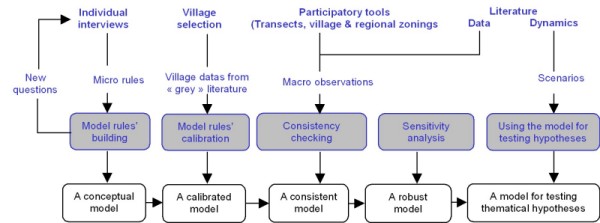
Figure 1. Overall field and modelling methodology of the SimSahel model - Both biophysical and socio-economic variables were defined through villagers' interviews: It means that for each interviewee talking about his/her production/economic activity (gardening, farming, livestock keeping and migration), we collected the economic and social factors he described as crucial for the activity. For instance, the access to land for a man was repeatedly described as possible only if he gets married. Marriage was described as conditioned by the payment of a dowry to the bride's family. If the father does not want or cannot provide the dowry, the young bachelor should get this money by himself, which is described as possible only through seasonal migration, meaning thereby to find a minimum amount of money for at least the bus ticket. Etc. Conditionality rules that define the way these collected variables are acting on people and the context of their application were built based on the number of times information was repeated by selected villagers during the interviews and through crosschecking between interviews. If a contradiction appeared between available literature and interviews, we selected the latter, considering that local answers belong to a coherent system. For instance, anthropological literature such as Harragin (2006) overestimates the solidarity, at least within the family level (money gifts or loans) while this solidarity seems during our interviews to not be a "between-equals" practice, following a "chief/clientele"-oriented relationship (children & parents, elders & youngsters, men & women). Behaviour algorithms were then designed and checked through informal meetings with different types of villagers, finally translated into UML diagrams and implemented.
- We separate the needed data according to the purpose and the subject of our research:
- The structure and framework are the context, which we did not investigate as it is not our research question: all data describing variables belonging to biophysical, demographic (both human and livestock) and economic (prices, costs) domains come from the literature on our study site (Gérard et al. 2001;Turner and Williams 2002;La Rovere and Hiernaux 2005;Gérard et al. 2007). We thereby assume their validity. Interviews results were used if literature does not provide the necessary data (For instance, no data were available on migration costs as no research has been assessed on this activity in the whole Western Niger).
- The second part deals with our very topic, i.e. the mechanisms of the relations between villagers and their environment and between themselves for the accesses to production and economic activities. Building these rules follows a field based inductive process (Chalmers, 1982) upon repeated and punctual observations is part of the confidence building process: a good reconstitution of the dynamic processes at the individual level testify for the good understanding of the system (an individual agent in the model does realize and experience the events the majority of the villagers of the same category experience: marriage after getting the dowry, access to land according to his family rank, etc.). Because of data uncertainty, these parameters are defined as relative to compare and hierarchize elements and factors for each village individual, thereby avoiding artificial threshold effects due to gaps between values coming from different data sources.
- Finally, we used theoretical hypotheses found in the socio-anthropological literature that describe social and environmental dynamics as supports for developing hypotheses and testing evolution scenarios.
Village & villagers' sampling
- 2.3
- Following these two points, we used several collective participatory tools to discriminate the villages of our study site, of which transects and three-days long visits but also Participatory Research Assessments (Chambers, 1994) and one Perception-Based Regional Mapping (PBRM:Saqalli et al. 2009): this last tool helps to build a classification of the different areas of the study site in which we eventually selected four relevant villages and hamlets on twenty-one. The selection criteria were size (big/small), access/no access to dry season cropping and roads: These two factors are mixed as good gravel roads cross only villages with access to shallow water. Meanwhile, no access to shallow water means to have no access to gardening while no gravel roads only means to have a more expensive access to migration), and inclusion/exclusion of the development projects' area, to reach the highest amount of diverse situations: As we focus on production & economic activities, access to road appears as crucial for the migration activity. Shallow water access in a village opens the possibility to garden, meaning that we had also to look after villages without this access. We hypothesized at the beginning of the work that access to development actions (access to inorganic fertilizers, credit, wages for working on agronomic trials) was a discriminative criterion while they appeared further that their extent was too small to actually be determinant).
- 2.4
- The villagers' sample was defined upon two-criterion stratification: Gender was repeatedly described during interviews as the fundamental criterion of discrimination with respect to the access to activities 'Women have only access to livestock keeping & gardening under certain conditions of age and family status. Men have access to farming, migration, livestock keeping under other certain conditions of age and family status as well). The second criterion is the level of responsibility, i.e. the number of dependents. We used semi-direct interviews focused on the main activity carried out by the interviewed person at the time of the interview: we have looked after the adequacy between the timing of the interviews and critical dates for each activity. Each person was interviewed once or twice depending on the number of activities he/she manages. 126 persons were interviewed, not including investigations on village history with elders and village chiefs. These field investigations were carried out from mid-2004 till the end of 2005. Individual interviews provided social rules that condition the differential access and power of each individual, which should be parameterized by field location- relevant figures, coming from our own interviews and other "grey" sources", i.e. reports from NGOs and other institutions working on site.
Overall description of the study area
- 2.5
- The area, called the "canton" of Dantiandou (approximately 2000 km2 and forty villages, hamlets and herder camps), is located 70 km northeast from the populated valley of the Niger River and Niamey, the capital city of Niger (800 000 inhab.). It borders to the east with the also populated fossil valley (56.36 inhab.km2), called "dallol", of the Boboye. The Fakara is crossed by a network of dry and thin talwegs (less than 5% of the total surface) where dry season gardening can be practiced. Wide sandy plains extend from these talwegs, representing 75% of the area and the major part of the arable land. The remaining 20% is covered by hardened lateritic plateaus, which can be used only for pasture and wood gathering (Loireau-Delabre 1998). The dominant ethnical group is the Zarma, mainly farmers with a growing livestock-keeping activity in their farming system (Olivier de Sardan 2003;Saqalli et al. 2009). Figure 2 shows the annual calendar for the different activities and the livestock movements as well as the main social annual events:
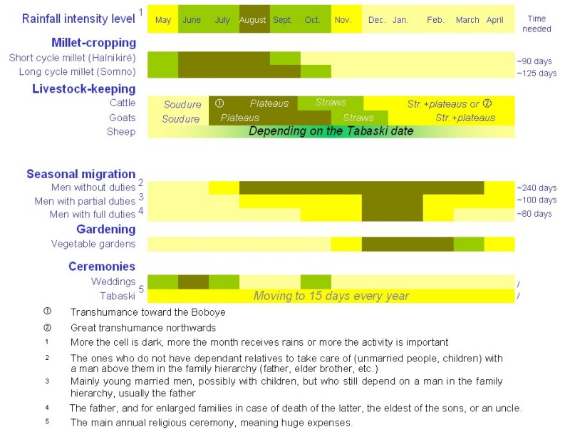
Figure 2. Annual calendar of the economic and social activities in the study site - 2.6
- Rainfed agriculture is the main activity in terms of land use and manpower requirement during the rainy season, from June to October (Tahirou 2002); it is a male adult occupation as they are always the farming manager, using their dependants as manpower. The main cereal is millet ( Pennisetum glaucum L. Br.), generally associated with cowpea as legume ( Vigna ungiculata L. Walp). Agriculture is managed in an extensive and anti-risk way: given the very low inherent fertility of the soils and the uncertain rainfall from 400 to 650 mm per year (La Rovere and Hiernaux 2005), farmers tend to clear and sow more surface than they can manage. Indeed, sowings can often fail and villagers have to repeat them several times in a parcel, up to five times a year (Loireau-Delabre 1998). During the era of spatial expansion, now coming to an end, villagers seeked to scatter their parcels in the village territory according to the distance to the village and soil quality mainly (Seybou 1993,Tahirou 2002). The local land inheritance system largely remains on the so-called "traditional" mode: the eldest male inherits all the land, which forces the other brothers to find land somewhere else. Thus, land remains within male lineages (Vanderlinden 2000).
- 2.7
- Seasonal migration occurs during the dry season, from October to May: male adults move to the Gulf of Guinea basin to find jobs (Mounkaïla 2003). The money they bring back is a big source of income for the whole Sahelian zone (Reardon 1994). According to our investigations in 10 villages, the percentage of adult men who migrate varies from 70 to 90% depending on the opportunities that their village offers for extra-agricultural income generation, which reduce the need for migration: presence of a market, of dry season activities provide opportunities. Seasonal migrants are rather young, between 20 and 40 years old: this slice constitutes a very important proportion of the population: in 1999, it constitutes 36.7 % of adult men (less than 70 years old) in the department of Kollo (formerly an «Arrondissement ») that includes the "canton" of Dantiandou (National Census 2001). Seasonal migration allows reducing the number of people feeding on the millet stock, leaving more food for those who stay home. Moreover, the money they bring back home, including clothing for the whole family, is an important contribution for the remaining family members, 290 € in average per family per year, or roughly 30 € per inhabitant per year, quite similar to the household income from migration in the contiguous Ouallam region (Ada and Rockström 1993). These funds seem not to have resulted in transformations of the local economic structure, according to our observations or analyses by other scientists, as significant increase of a sedentary kept livestock (Loireau-Delabre 1998). Based on our interviews, men try to get married as much as possible to reach the Muslim limit of four wives, as the main local wealth symbol, while they actually are all far from reaching this limit. Each marriage cost in average 1 150 € including the feasts, meals, gifts and the wedding chest, shared within the community. In addition, the dowry should be given to the bride's family (a sum traditionally equivalent to two bulls, i.e. almost 300 € but varying according to the lineages of the two families). Tabaski, the main Muslim feast, where a sheep should be sacrificed, is a time when sheep prices reach 5 to 6 times the usual price (from 22.5 € up to 135 €). As a local price indicator, a 80 kg bag of millet, which is enough to feed five adult persons for a month, cost from 13 to 35 €.
- 2.8
- Migrants also buy small ruminants as a means to save money during the rainy season, thereby protecting some money from the requests of the enlarged family (Pierret 1999). These savings are to be used mainly for paying the next migration travel expenses. Departure time is normally after crop harvest but many young bachelors frequently leave earlier, arguing that there is still a married male in charge remaining at home to handle crop harvest.
- 2.9
- Dry season vegetable gardening can be practiced only in some villages, which have access through wells to shallow groundwater (less than 6 m deep) in talweg fields. Social access to gardening is actually limited to married and respectable women with daughter-in-laws or unmarried daughters: by owing obedience, they free the elder from heavy domestic chores and give time for gardening. These women can borrow some land in the talwegs for gardening. This activity can provide an income quite equivalent to the male migration incomes: 52,50 € per woman cultivating per year on average.
- 2.10
- Finally, social activities and particularly marriage are essential to include: these are the ones that show the long-term efficiency of one's strategy: for instance, getting married with high lineage and status persons opens more possibilities to become relative with wealthier and "well-bred" families; in such places where incertitude facing hazards is the biggest threat, there is no better insurance system which is far more important than more individual wealth, a so uncertain and weak guarantee facing cropping, migration or even relatives' harassment hazards. This marriage-built insurance is even more important as time goes by. Fulfilling social duties when needed, such as funerals or "baptisms", means one's capacity to overcome the life incertitude and thereby is a great indicator of both his/her wealth and social capital according to villagers' perception, which increase the chances to be connected to more secure networks through marriage of himself and his/her relatives. Etc.
Agent based modeling methodology
- 2.11
- The selected ABM platform is CORMAS (Common Resources Management Agent-based System) developed by the GREEN team of the CIRAD-TERA (Bousquet et al. 2001). The model is split into an agro-ecological part and a socio-economic part (Figure 3):
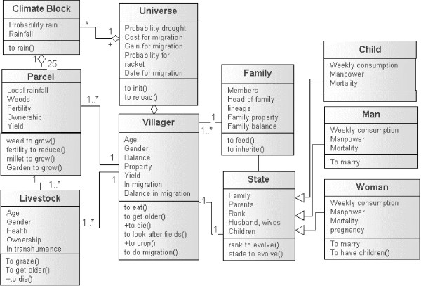
Figure 3. UML representation of the SimSahel model - 2.12
- Climate and land dimensions were simulated through the cellular automata matrix of the model, where each pixel is a parcel of the village territory. Livestock agent behaviour rules and biophysical constraint hierarchy are defined for each pixel based on the UML diagrams we built from criteria identified by the villagers and from literature: for instance, the list of the main factors to describe a piece of land (fertility, gardening capacity, reaction to rainfall, weeding, grazing and weed growth) were defined through interviews, but the description of these factors are defined through literature and unpublished research data.
- 2.13
- For the socio-economic part, we developed further the entity-centered ABM concept by choosing individuals as the main model agent entity and not households or families. The main principle we followed to implement field social observations is to translate them into sequences of behaviour without introducing external postulated rationality, as an empirical case study approach following Janssen and Ostrom (2006). No ultimate goal is defined, as all agents are reactive. No cognitive strategic aspects are developed onto marriage or inheritance procedures. Individuals were split into a productive part, named "Villager", and a social one, named "State". Agents are defined as equivalent, which means that they have the same attributes: only the values of these attributes vary, defining each agent and its characteristics.
- 2.14
- The SimSahel model was voluntarily conceived as a regrouping of numerous procedures. It means that in terms of UML representation, we may have to show a lot of small sequential diagrams, each one very simple but with a legend as big as the diagram itself! Therefore, the majority of the procedures are represented in their simplest shape, i.e. mathematical functions with several parameters, here with the exception of the complex villager rationality-based field extension.
Building an agro ecological module
- 2.15
- Fertility. We decided to create a vast environment so as not to limit villager agents in their quest for new fields. Therefore, one cannot see a transition of activity systems, which could have appeared if space were a limiting factor (Boserup 1980). The temporal scale is defined as one week for each time step. Table 1 shows the parameters used for the biophysical part of the model:
Table 1: Implementing the biophysical part of the model Rainfall Week: 0-21 21-29 29-33 33-37 37-41 41-45 45-52 Weekly probability of rain 0 25 75 25 0 Weekly mm equivalent of rain per pixel r(t) 0 20 40 65 40 20 0 Annual rainfall drought factor From 67% to 125% of the week rain Fertility affecting events Initial fertility factor Fp Valley Fp = 2; plain Fp =1 Rain Rainy season (after the first rain occurring in the year)
f(t+1) = f(t) × (1+ r(t) / (mean rainfall × 10) (mean rainfall = 550 mm)Sowing or weeding f(t+1) = f(t)-(1/1000) Harvesting f(t+1) = f(t)- (parcel yield/1000 × Fp) Weeds and grass growth (adapted for discrete simulations from Lassina (1992), Ahonon (1994) and Delabre (1998) (weeds value (t+1) / weeds value (t)) > 1
If True: f(t+1) = f(t) - (weeds value(t+1) / weeds value(t) - 1
If False: f(t+1) = f(t)Shrubs growth (adapted for discrete simulations from d'Herbès et al. (1997) Montagne and Housseini (1998) and Wesel et al. (2000) (Shrubs value(t+1) / shrubs value(t) > 1
If True: f(t+1) = f(t) - (shrubs value(t+1) / shrubs value(t) - 1
If False: f(t+1) = f(t)Manure (adapted for discrete simulations from Pierret (1999) f(t+1) = f(t) + (1/1000 × (1 - ratio Manure(t))
With ratio Manure effect on yields adapted from Gérard (2005)Animals manuring and grazing impact Surface considered S "Dry" cattle Dry season: transhumance Rainy season: S = non cultivated plain and valley Calves and milking cows Both seasons: S= non cultivated plain and valley Goats Both seasons: S= Plateau, plain distant from at least two pixels from cultivated fields or garden Goats Sheep Both seasons: S= Plateau, plain distant from at least two pixels from cultivated fields or garden Both seasons: S= Valley and village only - 2.16
- The model is spatialized through a dynamic 100*100 pixels map as the main interface for the visualization of interactions. The village territory is spatially described through a layer where each cell has an initial agro-pedological fertility potential P: the plain (P = 1), the valley (P = 2), the village and the plateau (P = 0), a simplification from the soils qualitative description of GlÄttli (2005). A "parcel" entity is symbolized by a cell of the map and can be owned by a villager agent for farming. Each pixel fertility value is initially equal to the parcel's potential and it then varies according to the vegetative growth of grass and shrubs in the pixel, defined by the local pixel rainfall and the initial fertility, the cropping impact if the land is owned and cultivated (sowing and preparing the land, weeding/not weeding, harvesting) and the manure left by livestock or by villagers.
- 2.17
- The fields' manuring and grazing impact is defined through an estimation of the surface, which can be grazed by the different species as described in Table 1. At each step, this surface is grazed depending on the species (i.e. preferentially shrubs for goats, preferentially grass for the others) along a ratio between the surface and the number of animals of each species. Cattle are differentiated between a calf and milking cow group, staying on the village territory all along the year, and a "dry" group, leaving for transhumance during dry seasons. The manure from the remnant herd is then defined for each animal specie for each pixel: half of one animal manure is spread in grazed areas (at day time and the other half in corrals at night (Ayantunde et al. 2000; Ayantunde et al. 2002): this last part of the manure is then spread solely on the fields of the animal owner, which means that this action leads to a potential differentiation between fields according to the field owner's herd.
- 2.18
- Rainfall. This factor can be considered as the unique climate factor to impact on local systems. As it has a high spatial and temporal variability, the objective was to simulate the seasonal rain distribution and variability as observed from ICRISAT 20 years long rainfall data, as well as the spatial correlation of rain events at the village level. Climate simulation is done through a 5 × 5 pixel "Climate Blocks" matrix. For each time step, i.e. each week, each block receives a rainfall probability, and if it rains, a probability for the quantity of rain according to the time of rainy season. The probabilities and the weekly rain quantity are determined from the weather means database from ICRISAT (La Rovere and Hiernaux 2005, Gérard et al. 2007), allowing each pixel to receive the annual average rainfall value and the intra annual variability as collected at ICRISAT. Both probabilities are then affected by a drought factor, randomly defined for the whole territory at the beginning of each year; that factor determines the rainfall variation for the year to come and varies from 80% to 130% of the 500 mm average rainfall, thereby reconstituting the site inter annual rainfall variability. Figure 4 shows the map of the village territory and the rainfall for one year.
Figure 4. Map of the village territory and the rainfall for one year Implementing social relationships within families in a Fakara village
- 2.19
- At the model initialization, fifty villager agents are created in the virtual environment. Villager agents are age-defined (between 1 and 55 years old) and gender-defined. A mortality probability is also defined, growing along the age of the agent, eventually allowing it an average life expectancy of 48,5 years-old for both genders as described for the arrondissement in the UNDP report (UNDP 2005). Each male adult agent is characterized by a randomly defined lineage value from 1 (the best) to 4 (the lowest), as a measure of the power of each big kinship group in the village. This value is transmitted to all his progeny and his wives. It can happen that there are more (or less) male than female adult agents in one simulation, or lineages can have different sizes. Each male adult agent takes one piece of land as a new property, containing several parcels (According to observations, women do not own land but can only borrow it for gardening). The number of the latter is defined according to the lineage value, between 3 and 7 parcels, i.e. 3 to 7 map cells. The size of the land property can extend thereafter according to the available family manpower and the lineage value; the land is then chosen through a comparison within the not appropriated parcels available of a formula combining the distance to village and the fertility of the parcel (Loireau-Delabre 1998 p.170-186). Male adult agents can then get married and create a family with themselves as the head.
- 2.20
- After the model initialization, gender and family rank for a villager agent are the most important factors within the village context (Olivier de Sardan 2003). They determine the access to all the social and/or economic activities, i.e. marriage, property, food and money redistribution, millet farming and migration for men, gardening for women.
- 2.21
- Ranks are defined for all child agents but vary for all adult agents in each family. They are updated at the beginning of each time step, according to newborns, new marriages, reaching adulthood and deaths. By default, the ranking index is equal to 1, the highest rank, i.e. the head of the family; from then on, the following rules are applied:
- For each male adult agent, the ranking index increases by one point if the father is alive and for as many points as the number of elder brothers he has got.
- At wedding time, female adult agents move to their new husband's family. Ranks of married female adult agents are equal to their husbands' rank, plus one point.
- Ranks of unmarried female adult agents, i.e. unmarried sisters in a family, are equal to the youngest adult male of the brotherhood plus one point.
- From then on, dependent relatives are defined for each adult agent: they are members of the same family, with a lower rank, and related to him/her by marriage or as progeny.
- 2.22
- The marriage status is thereby a very important criterion as it is the only act through which a villager increases his/her family rank level. This is true for both men (married men may inherit lands or appropriate new free parcels, get access to child manpower and children-related-prestige) and women (married women have better ranks, have children and thereby get access to the related manpower for gardening and children-related prestige). As we do not focus on marriage rationality, we did not implement a negotiation between candidates as theorized by Simon (1955) and implemented for agent-based simulation by Small (1999) or White (1999), and we rather used a simple assortative mating principle following Becker (1974): marriages are matched through a comparison between mating members upon a same reference value system. As a sequential principle, this method has the lowest emergence effect, is simple and fits better with the observed situation. After majority (16 years old), marriage can occur if the young male adult agent can pat the dowry, through the money he brought back from migration for instance. Muslim people marry up to four times if they can afford the costs. Males sort the female adult bachelors according to their family characteristics (lineage, size, family wealth, livestock and land) and their personal ones (family rank, livestock). As a strict condition to own land and thereby to become a "citizen" in the village, each male adult agent has to marry at least once. Earning enough money to afford the dowry is therefore vital for each bachelor in his village. As described above, the dowry reaches 300 € but varying according to the families' lineages.
- 2.23
- In the simulation, only married women can have children. For each time step, the pregnancy probability is defined as equal to 1/52 per week. At childbirth, a new villager agent is created, with a random gender, as a member of his family, of his lineage and of the village. Simulated ceremony costs are taken from the family balance as equivalent to the cost of a sheep.
- 2.24
- Inheritance is important as well considering the power land have within the village and the family. It thereby has sense only in the case of the death of a land or a livestock owner. We have followed a "brutal" version of the common law: the married elder son (even he is a widower) receives the whole heritage, leaving the others to exploit new lands somewhere else (Luxereau and Roussel 1997). As long as there remain adult family members, the one whose rank is the best becomes the new head of the family and receives the land. If there are no adults anymore within the family, the land is given to the chief of a family from the same lineage. The heir adopts the remaining children. Livestock inheritance follows a different mechanism: it is shared equally among the corresponding gender as observed locally: female owned livestock to female heirs, male owned livestock to male heirs.
- 2.25
- Each villager agent has an individual food balance, which defines how much it has to feed itself. Food redistribution, related to the number of dependents, is the most important hierarchy criterion within a family. At each time step, each adult agent classifies its dependent relatives with a negative balance taking into account the "social distance" between them, i.e. the difference of social ranks within gender and age groups: The food manager feeds firstly male adult agents, then his wife/wives, then other married female adult agents, then unmarried ones (his adult daughters or great-daughters) and finally children. While men are not present in the family (i.e. during migration periods), the food distribution manager is the woman with the highest rank, usually the wife of the head of the family. This is consistent with the observed commensality procedure in villages and particularly in the biggest families: the strongest productive elements seem to be favored in a family: men eat alone before women who feed babies, and finally children eat the remaining food). If a family member balance is not fulfilled by redistribution and its value is negative at the end of the step, the villager entity is suppressed and considered as dead. Table 2 presents the socio-economic factors of the model:
Table 2: Parameters used for the socio-economic part of the model Marriage Assortative sequential criteria for discriminating female bachelors Limitations Limited to four wives Livestock effect A (i,t) = Bfi (t)/8+Ofi(t)/16+ Bi(t)/4+Oi(t)/8 with:
Bfi (t): bovine livestock owned by the family
Ofi (t): ovine and caprine livestock owned by the family
Bi (t): bovine livestock owned by I
Oi (t): ovine and caprine livestock owned by iFamily situation effect F (t) = (Family size - Rank (i)) - Children size (i) Family lineage effect L = (lineage amount (4) +1) - Li with:
Li: family lineage of ITotal Vi = (A (i,t)+ F(t) ) * Li Ceremony costs 1150 € (same amount for all, independently from lineage, according to the observed village-level agreements between families) paid by the head of the household Dowry costs 300 € (same amount for all, independently from lineage: it is an assumption as differences according to family situation may exist Property access (after initialization) Maximum "allowed" property Family lineage effect (i) * Family total manpower (i,t) * R with:
R: randomized value 50% chances: R =1; 25%: R= 1.5; 25%: R=2)"Semi-randomized" research effect: Research of new parcels starts from the village pixels. The number of trials for a villager I: N = Family total manpower (I,t) Parcels comparison criteria: C (j,t) = Fertility (j,t) - Distance to Village (j) Food and money redistribution Individual rank based assortative classification of the dependents Millet farming and migration for men Only the man with the highest rank (or by default his widow) can own and by then manage the land by ruling the dependent male manpower Gardening for women Only the woman with the highest rank can borrow and by then manage a garden by ruling the dependent female manpower Simulating the villagers production activities
- 2.26
- Agriculture. Only male adult agents can crop millet fields and only female adult agents can garden (that villager agent has the power to manage that land, but it doesn't mean that he owns total rights on the yield). Only household heads can extend the family property according to their family needs its manpower, following Figure 5:
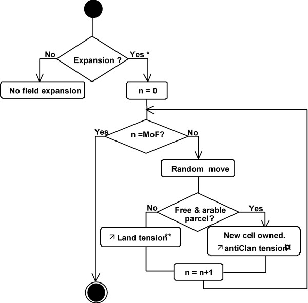
Figure 5. UML sequence diagram of the field expansion practice of an individual agent in the SimSahel model - 2.27
- The effect of this practice can be seen along sixty years of simulation. Figure 6 shows the expansion of the fields along the sixty years of simulation:
Figure 6. The expansion of fields during sixty years of simulation - 2.28
- Therefore, one parcel produces only if it has either been appropriated or borrowed by a villager agent. The diagnosis of available manpower depends on the chosen family structure. Each week, the villager agent observes his parcels' status and calculates the available manpower he can use (his own and his dependent relatives who are available, according to the family structure). He then classifies priorities and chooses the field so as to minimize the loss of production over all his fields. For instance, if a villager agent sees several of his parcels invaded by weeds and if he does not have all the required manpower, he chooses to weed the parcel with the most important potential loss, i.e. the most fertile parcel invaded by weeds. Crop growth is governed by the available manpower a villager agent can mobilize to carry out the right cropping action at the right time, by rainfall and by the fertility rate at each time step. Crops yields result from a combination of the crop growth rate, weeds and fertility effect rates. Weeds evolve according to parcel fertility, rainfall and the farmer agent weeding actions (Lassina 1992; Montagne and Housseini 1998; Sangaré et al. 2001; Schlect et al. 2006). They affect millet production only if the millet growth level is lower than the weed growth level.
- 2.29
- For their dry season vegetable gardens, female adult agents follow an equivalent sequence of actions. Only female adult agents with stepdaughters or with unmarried daughters at least 12 years old can have access to gardening. These can mobilize the available female manpower from then on in a similar fashion than the head of the family for millet farming.
- 2.30
- Migration. Only male adult agents more than 16 years old have access to the migration activity. The price for the roundtrip travel is the major constraint for leaving. The date of departure depends on the family rank, i.e. the number of dependent relatives. To come back, the migrant should overcome two constraints: (i) for prestige reasons, a male adult agent cannot come back in the village without a minimum amount of money, at least the roundtrip ticket for the next migration, i.e. 2* 45 €. (ii) Each male adult agent has a 1% probability to be racketed by the different customs services he meets. To simulate the migration activity, we defined a weekly gain accumulation function as follows:
Gi (t+1) = Gi (t) + gi (t) * [1+(Ni / 10)]
With: Gi (t+1) and Gi (t) gains of the individual i, respectively at time t+1 and t, Ni the number of years of experience of the individual i, gi (t), the weekly gain: gi (t) = 6 from the beginning of July to mid-December (coffee harvesting period), gi (t) = 15 from mid-December to mid-February (cocoa period), gi (t) = 2 from mid-February to the end of June (no harvests).
- 2.31
- Livestock keeping. It is here limited to a saving scheme, except its impact on the fertility process. Each year, individual gains (crop yields for family heads, migration for men, gardening for women) are transformed into livestock, with a depreciation factor. Villager agents buy animals after crop harvest, when they have grain to sell; however, it is the time when millet price is the lowest (13,75 € in average per 80 kg bag). When the granary is quite empty, they sell animals to buy millet, but at that period, millet price is high (27,50 € per bag on average). This 50% loss can be considered as a livestock keeping cost. For instance, the ceremony costs and the dowry a bachelor should pay are simulated through an equivalent amount of money. Coming back from migration, the migrants buy small ruminants they feed during the rainy season. At harvesting time or sometimes before, they are sold to pay the ticket for the next migration. Animal fattening is considered as compensating the 50% loss.
Results and discussion
-
Sensitivity analysis on several selected parameters: testing the SimSahel robustness
- 3.1
- We have realized a sensitivity analysis on several parameters. A complete sensitivity analysis is yet to be achieved following the three steps of Railsback et al. (2006), i.e. (1) model sensitivity to each parameter, (2) interactions to parameter pairs, (3) reaction of management alternatives to parameters perturbations. Here a first step is proposed by testing parameters we considered as thematically crucial in the model on which we showed the results of four of these output variables, as they have interesting impact properties on the model system. The first two are related to local biophysical factors (livestock fecundity, annual drought factor), the two other ones relate to parameters that condition the villages' society (migration cost, marriage cost). The other tested parameters are related to other specific scenarios and show a high robustness, and even a stability of the results facing variations of the considered parameters. Twenty simulations of each situation were carried out and the mean results at the end of the simulations are shown in Figure 7. The significance of the results is tested with a variance analysis (ANOVA) at 95% of significance, using MATLAB© (standard errors not shown for clarity purposes). The factors' variations occur at the beginning of each simulation:
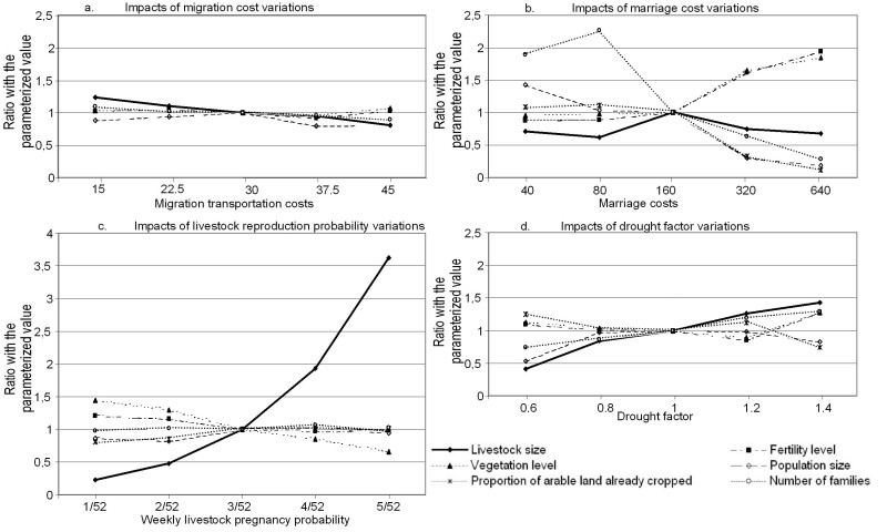
Figure 7. Results of the sensitivity analysis on several selected parameters - 3.2
- In Figure 7a, migration costs are varying around the parameterised value of 30 KFCFA (~45€): The livestock herd size and the number of families decrease significantly with migration cost: the easier to migrate, the more migrants can save money through livestock and the more easily they can get married. The population level reaches a peak around the mean value of 30 KFCFA. We can suppose that it is due to two effects: the easier it is to migrate, the more migrants stay abroad, thereby reducing their time in the village having babies (their presence is necessary in the model for women to get pregnant). On the other hand, the more it is difficult to migrate, the more it is difficult to get married and have children as well. Therefore, the cultivated land proportion is not significantly affected: the more it is difficult to migrate, the more the population crop thereby compensating for the reduction of the population and of the number of families. These variations have no significant impact on vegetation and fertility because most of this additional livestock is based on cattle leaving the "terroir" for transhumance during 9 months each year.
- 3.3
- Figure 7b shows the impact of marriage cost variations around the parameterized value of 160 kFCFA (~240€). Apart from the 40-kFCFA case, the increase of the marriage costs implies a reduction of the population because of the reduction of the number of marriages, and thereby the herd size, the fertility and the vegetation indices. At 40 kFCFA, this value is so low that this is not anymore a constraint for marriage occurrence. Because of polygamy, men get married up to four times as soon as possible, which induce a higher demography.
- 3.4
- Livestock reproduction variations around the parameterised value of 3/52 per week (Figure 7c) have obviously a large effect on the number of animals. However, increasing the number of livestock has virtually no impact on any of the other factors except a limited but significant decrease of the vegetation. This lack of effect is also due to transhumance.
- 3.5
- Figure 7d shows the results of the test of different values of the drought factor around its value of 1: livestock and the number of families continuously increase. Environmental factors seem paradoxically not to be significantly affected as well as the population: actually, a drought of 0.6 reduces agricultural activities to the benefit of migration and livestock keeping activities, thereby reducing the impact of human activities on the resources of the "terroir". On the other hand, a high drought factor, meaning a wetter environment, increases the two environmental indicators (vegetation and fertility).
- 3.6
- These sensitivity test results provide some confidence on the model, allowing us to consider it as quite well constrained by the different parameters of its structure. The model is not very sensitive to changes on the considered parameters, meaning that differences in simulation outputs between scenarios are meaningful. One may note that the parameters from the literature that belong to biophysical disciplines condition so strongly the system structure that they actually create new environments and contexts. Other parameters do have an effect on only some portions of the system.
Model confidence building: testing the SimSahel consistency with external available data
Comparing simulation outputs based on two observed family organization types with external data
- 3.7
- This confidence-building step is carried out by comparing simulation outputs of two scenarios, based on two different family organizations: Our field observations let us to notice the huge gap between the usual African family archetype and the observed dominant structure, which correspond to a multi-decision family organization where there is a collective organization but not based on a cooperation efficiency as defined by Pareto (Sen 1983 in Meignel 1993). Two family structures were compared:
- A unitary concept of the enlarged and patriarchal family, still the main concept of African families as used by development agencies, hereafter referred to as the Unitary Family Structure (UFS).
- A collective non-cooperative family, which is nowadays the most common in the study region (Tahirou 2002 p.23), and referred to as the Non Cooperative Family Structure (NCFS) scenario. They constitute 76% of the families of our sample.
- 3.8
- For each scenario, fifteen simulations were run for a period of sixty years (i.e. two generations) each of 3120 time steps. The two scenarios, each one with one family organization, are compared to each other and with literature data. Results are presented in Figure 8:
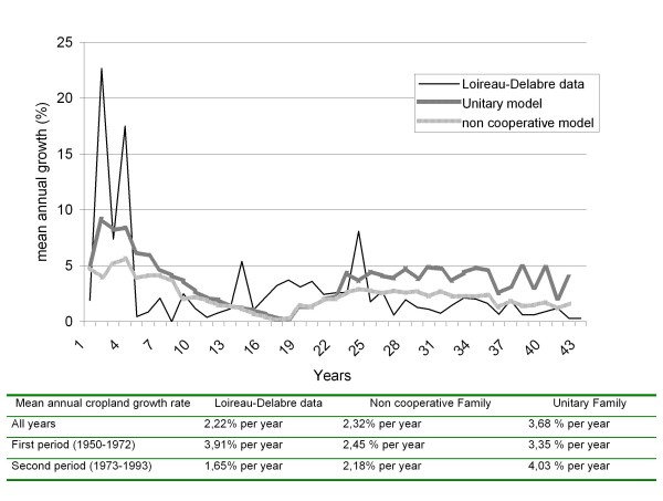
Figure 8. Comparison of the annual growth rate of cultivated land for the two scenarios simulation outputs and interpolated data from Loireau-Delabre (1998) - 3.9
- The two scenarios lead to different population growth rates, from 50 inhabitants at the beginning to 472 inhabitants (± 240) for the UFS (average growth rate of 3,91% per year), and to 176 inhabitants (± 81) for the NCFS (2,19% per year). The General Census of Niger reports growth rates of 3,44% per year over the 1977-1988 period and 2,75% per year over the 1988-2001 period for the Tillabery region but, within this region, 2,3% per year for the Kollo department, which includes the Fakara. Assuming that one has evolved in reality from a dominant UFS type to a dominant NCFS, then we may consider that the model has correctly simulated the demographic growth and the impact of the family organization on this growth.
- 3.10
- Loireau-Delabre (1998) being currently the best reference on the Fakara recent history, we compare the evolution of the acreage of cultivated fields that she simulated and the model simulation results. Loireau-Delabre acreage is derived from five aerial photo interpolations (1950, 1965, 1975, 1985, 1992), combined with demographic data from the national Census and village demographic trends from Guenguant (these latter results were afterwards published in Guenguant et al. (Guenguant 2002). The Loireau-Delabre results for the first 20-year period show a similar cultivated surface growth rate than the one from the UFS simulation results, with a value higher than 3% per year. For the next 20-year period, the Loireau-Delabre results show a decrease of this rate that corresponds better with the simulation results of the NCFS, with values around 2% per year, whereas the UFS scenario results in an acceleration of this cropland expansion. Loireau-Delabre explains the observed decrease with the lack of potential arable land. This phenomenon appeared in our simulations after 50 or 80 years depending on the chosen scenario. Meanwhile, social constraints we implemented can be considered as anticipators of the land tension: more a family have social constraints (no inheritance, no support from relatives, low manpower), more land is difficult to get. The NCFS scenario illustrates more the impacts of such social constraints on the decrease in population growth, mainly due to the lack of support for new family creations. This constraint was implemented based on the results of our investigations: one can nowadays observe a clear lack of solidarity between rich and some particularly poor families, with little land and/or manpower and/or having suffered low crop yields recently. We therefore can suppose that such families are only precursors of the future, when land constraints will be stronger and generalized, as Yamba (2005) described it for the Maradi region.
- 3.11
- Analysing these results, one may consider the hypothesis of a shift in family organizations, from the patriarchal one to the mononuclear one during the 70's, meaning that famines that occur in this decade had only catalytic effects on a phenomenon that would have been realized anyhow.
Comparing simulation outputs based on two observed development project actions with external data
- 3.12
- We carried out this second confidence-building test by comparing simulation outputs of two scenarios with other scholars' field results. For each scenario and site, thirty simulations were also run for a period of sixty years (i.e. two generations). These scenarios are related with two "currency" possibilities:
- A scenario where each individual currency (i.e. a tool to evaluate the relevancy of an activity) money, whatever its nature (cash, livestock, millet in the storehouse), hereafter named FM (Fakara Money).
- A scenario where each individual currency is reputation, i.e. elements that includes its wealth but also social position (rank, lineage) and its capacity to fulfill social duties (supporting relatives, sacrificing livestock for ceremonies, etc.), hereafter named FR (Fakara Reputation).
Table 3: comparison of the field results from our investigations and other scholars and simulation outputs FAKARA without projects Family size Family manpower (in FLU) Average livestock owned per family % Area corralled with livestock Household Sample size Cattle Goats Sheep Loireau-Delabre (1998) Zarma villagers only 9,1 6,8 1,3 2,1 36,9 221 La Rovere (2001) p.47/ Zarma villagers only 8,6 4,8 0,7 0,1 0,1 10,2 366 Tahirou (2002) NA 7 3 4 NA 100 Own field results 8,2 5,2 2,0 1,41 0,2 NA 67 FRC (simulated) 7,2 ± 0,2 5,7 ± 0,5 3,4 1,17 0,2 8,9 NR FEC (simulated) 7,1 ± 0,2 5,4 ± 0,5 3,2 0,93 0,3 15,4 NR FRFW (simulated) 6,9 ± 0,2 5,6 ±0,5 2,8 1,37 0,5 10,4 NR FEFW (simulated) 7,0 ± 0,2 5,6 ± 0,4 2,4 0,80 0,5 8,1 NR FLU: Farming Labor Unit; NA: no data available. NR: not relevant - 3.13
- Data reported by different authors are actually highly variable among each other, particularly regarding herds. Our results are consistent with data from three authors having investigated in our site, i.e. the results fall within their range. The difference between our field and simulation outputs is that, thanks to our hypotheses, we have corrected the probable interview biases of overestimating the proportion of enlarged families and underestimating the child manpower. Concerning our simulation outputs, livestock distribution and size fit better with observations of Loireau-Delabre (1998) and Tahirou (2002) whereas the other simulated factors (family size, family manpower and proportion of the "terroir" corralled with livestock) fit better with La Rovere (La Rovere 2001).
- 3.14
- We suppose that the bigger livestock herd in our simulation outputs reveals the importance of the "transhumant offshore cattle savings" that may be omitted by interviewees. The lower family size in our simulation outputs reveals the proportion of small families that are usually less often interviewed. Finally, the higher manpower level in proportion of the family size in our simulation outputs is due to the inclusion of the child manpower but also to the fact that we considered that women and men have the same Farming Labor Unit.
Conclusion
- 4.1
- The model appears fairly robust regarding several parameterized crucial indicators and sensitive enough regarding several literature-originated indicators. The confidence building steps show that the model reasonably reproduces the dynamics of local situations. However, the latter steps have also shown the difficulty to obtain "real" figures: the three authors we cited above obtained very different figures for crucial parameters. Such differences may be due to the inherent effect of the interview processes, the issues and the methodology. Thanks to its empirical approach and its balanced conception between sociology and agro-ecology, as long as the model is used to simulate rural societies of the Nigerien Sahel and to test scenarios based on reliable theories and conceptions about the same geographical and sociological context, it is believed that this tool can be used to estimate the relative "weight" and power of the various considered factors. Therefore, the model should be considered as an efficient "trend provider" but not as an "absolute figure provider".
- 4.2
- The several field and data constraints orientated our research on the decision processes that occur within village populations. In any case, agent-based model simulation outputs cannot be used to prove assertions. A complete methodology of integration between sociology, game theory and rural development is still to be built: simulating a society and building an agro-ecological model have different scientifically relevant criteria. However, there are no better tools yet than ABMs to combine qualitative information and quantitative data. In a context where the majority of development decision-makers have a technical background, ABMs are a useful interface to introduce social stakes in development projects.
Acknowledgements
-
Authors are thankful and indebted to all interviewed villagers for their great patience. We acknowledge the contribution of Dr. Tahirou for his valuable advice on anthropological questions, Pr. F. Gaspart (UCL), P. Bommel and Dr. C. Le Page (CIRAD-TERA) for their helpful comments on the first versions of the manuscript. Financial support comes from the Belgian DGCD ICRISAT-led "Decision-support program".
This article has been translated into Estonian.
Notes
-
1 The most surprising example may be the fact that three research and development projects deal with climate change effects on West Africa, when n equivalent actions concern the demographic growth, the highest in the world (for instance, 7.1 child per woman in Niger)
References
-
ADA, L and ROCKSTRÖM, J (1993) Diagnostic sur le système agraire du Zarmaganda central. M. Sc. in Agronomy, INA-PG, Paris, France.
AHONON, D (1994) Etude de la régénération des ligneux dans 7 jachères sur le terroir de Banizoumbou. M. Sc. in Agronomy, Université Abdou Moumouni, Niamey, Niger.
AYANTUNDE, A FERNANDEZ-RIVERA, S HIERNAUX, P VAN KEULEN, H and UDO, H M J (2002) Day and night grazing by cattle in the Sahel. Journal of Range Management. 55 (2) 139-143. [doi:10.2307/4003350]
AYANTUNDE, A WILLIAMS, T O UDO, H M J FERNANDEZ-RIVERA, S HIERNAUX, and P VAN KEULEN, H (2000) Herders' Perceptions, Practice, and Problems of Night Grazing in the Sahel: Case Studies from Niger. Human Ecology. 28 (1) 109-130. [doi:10.1023/A:1007031805986]
BAH, A TOURé, I LE PAGE C ICKOWICZ, A and DIOP, A T (2006) An agent-based model to understand the multiple uses of land and resources around drillings in Sahel. Mathematical and Computer Modelling. 44 513-534. [doi:10.1016/j.mcm.2005.02.014]
BACAËR, N BAH, A and MAHAMANE, A (2005) Fuelwood harvesting in Niger and a generalization of Faustmann's formula. Comptes Rendus Biologies 328 379-385. [doi:10.1016/j.crvi.2004.10.017]
BAKAM, I KORDON, F LE PAGE, C and BOUSQUET, F (2000) Formalisation de modèles multi-agents par les réseaux de Petri: application à l'étude d'un système de gestion de la chasse à l'Est-Cameroun. In: CORENTHIN A and PHILIPPE B (Eds). Proceedings of the 5th African Conference on Research in Computer Science CARI'2000 Antananarivo, Madagascar, Inria Editions, pp: 265-272.
BARRETEAU, O BOUSQUET, F MILLIER, C and WEBER, J (2003) Suitability of Multi-Agent Simulations to study irrigated system viability: application to case studies in the Senegal River Valley. Agricultural Systems 80 (1) 255-275.
BECKER, G S (1974) A Theory of Marriage: Part 2: Marriage, family human capital and fertility. Journal of Political Economics 82 (2) S11-S26. [doi:10.1086/260287]
BERGER, T (2001) Agent-based spatial models applied to agriculture: a simulation tool for technology diffusion, resource use changes and policy analysis. Agricultural Economics 25 (2-3) 245-260. [doi:10.1111/j.1574-0862.2001.tb00205.x]
BIERSHENK, T CHAUVEAU, J-P and OLIVIER DE SARDAN, J-P (2000) Courtiers en développement; Les villages africains en quête de projet. APAD-Karthala, Paris, France.
BOSERUP, E (1980) Evolutions agraires et pression démographique. Cambridge Geographic Studies, Cambridge, United Kingdom.
BOUSQUET, F LIFRAN, R TIDBALL, M THOYER, S and ANTONA, M (2001) Agent-based modelling, game theory and natural resource management issues. Journal of Artificial Societies and Social Simulation 4 (2) https://www.jasss.org/4/2/contents.html
CHALMERS, A. F (1982) Qu'est-ce que la science ? Popper, Khun, Lakatos, Feyerabend. 2nd edition. La Découverte, Paris, France.
CHAMBERS, R. (1994) Participatory rural appraisal (PRA): Analysis of experience. World Development 22 (9) 1253 1268. [doi:10.1016/0305-750x(94)90003-5]
D'AQUINO, P LE PAGE, C BOUSQUET, F and BAH, A (2003) Using self-designed role-playing games and a multi-agent system to empower a local decision-making process for land use management: The SelfCormas experiment in Senegal. Journal of Artificial Societies and Social Simulation 6(3)5 https://www.jasss.org/6/3/5.html
DELABRE, E (1998) Caractérisation et évolution d'écosystèmes anthropisés sahéliens : les milieux post-culturaux du sud-ouest nigérien. PhD in Ecology, Université Pierre et Marie Curie Paris 6, Paris, France.
D'HERBES, J-M AMBOUTA, K J M and PELTIER R (1997) Fonctionnement et gestion des écosystèmes forestiers contractés sahéliens. John Libbey Eurotext, Paris, France.
DROGOUL, A VANBERGUE, D and MEURISSE, T (2000) Simulation Orientée Agent: où sont les agents? Seminar Report, Université Paris 6, Paris, France.
GASTELLU J-M (1980) Mais où sont donc ces unités économiques que nos amis cherchent tant en Afrique? Cahiers des Sciences Humaines de l'ORSTOM 17 1-6.
GASTELLU, J-M and DUBOIS, J-L (1997) En économie: l'unité retrouvée, la théorie revisitée. In: Ménages familles en Afrique: Approches des dynamiques contemporaines. Les Etudes du CEPED 15 75-97.
GéRARD, B HIERNAUX, P MUEHLIG-VERSEN, B and BUERKERT, A (2001) Destructive and non-destructive measurements of residual crop residue and phosphorus effects on growth and composition of herbaceous fallow species in the Sahel. Plant and Soil 228, 265-273 [doi:10.1023/A:1004876032203]
GéRARD, B (2005) ICRISAT agronomic results from the global linear modelization of demonstration tests fields' data. ICRISAT report. Niamey, Niger.
GéRARD, B FATONDJI, D DANDOIS, C MANYAME, C and BIELDERS, C (2007) Toward farm specific recommendations for the use of mineral fertilizers in Sahelian crop-livestock systems. Proceedings of the 16th C.I.E.C. Gent, Belgium
GLÄTTLI, S (2005) Méthodes et outils pour faciliter l'échange de savoir entre spécialistes de conservation des eaux et sols et agriculteurs sur la gestion durable des sols au Niger, Afrique de l'Ouest. Une analyse ethno-pédologique pour démontrer les différentes perceptions du sol. M. Sc. FakultÄt der UniversitÄt Bern, Center for Development and Environment (CDE), Bern, Switzerland
GUENGUANT, J-P BANOIN, M and QUESNEL, A (2002) Dynamique des populations, disponibilités en terres et adaptation des régimes fonciers : le cas du Niger. ONUAA -FAO report, Rome, Italy
HARRAGIN, S (2006) The Cost of being Poor: Markets, mistrust and malnutrition in southern Niger 2005-2006. Save the Children report on the Niger crisis.
JANSSEN, M A and OSTROM E (2006) Empirically Based, Agent-based models. Ecology and Society. 11 (2) 24-37
KONING, N and SMALING, E (2005) Environmental crisis or 'lie of the land'? The debate on soil degradation in Africa. Land Use Policy. 22 (1) 3-11. [doi:10.1016/j.landusepol.2003.08.003]
LAMBERT, S and SINDZINGRE, A (1995) Droits de propriété et modes d'accès à la terre en Afrique: une revue critique Cahier d'Economie and de Sociologie Rurales 36 (3) 95-128.
LAMBIN, E ROUNSEVELL, M D A and GEIST, H J (2000) Are agricultural land-use models able to predict changes in land-use intensity? Agriculture, Ecosystem and Environment 82 (1-3) 321-331. [doi:10.1016/S0167-8809(00)00235-8]
LA ROVERE, R and HIERNAUX, P (2005) Co-evolutionary scenarios of intensification and privatization of resource use in rural communities of southwestern Niger. Agricultural Systems 83 (3) 251-276. [doi:10.1016/j.agsy.2004.04.003]
LA ROVERE, R (2001) Livestock roles and agro-environmental sustainability of Sahelian Niger mixed crop-livestock systems under intensification. Ph.D. in Geography International Livestock Research Institute, University of Hohenheim, Germany.
LASSINA, O (1992) Etude des relations pluviométrie-phénologie-production dans la zone sud ouest du Sahel nigérien. M. Sc. in Forestry, Université Abdou Moumouni, Niamey, Niger.
LAVIGNE-DELVILLE, P (1999) Impasses cognitives et expertise en sciences sociales: réflexions à propos du développement rural en Afrique, GRET Coopérer aujourd'hui 9.
LAZAREV, G and ARAB, M (2000) Développement local et communautés rurales: approches et instruments pour une dynamique de concertation. Réseau Interdisciplinaire de Soutien au Développement Participatif, Paris, France.
LOIREAU-DELABRE, M (1998) Espace ressources usages, Spatialisation des interactions dynamiques entre les systèmes sociaux et les systèmes écologiques au Sahel nigérien, site de Banizoumbou, Niger. Ph.D. in Geography Université Paul Valery, Montpellier, France.
LUXEREAU, A and ROUSSEL, B (1997) Changements écologiques et sociaux au Niger. L'Harmattan, Paris, France.
MATTHEWS, R (2006) The People and Landscape Model (PALM): Towards full integration of human decision-making and biophysical simulation models. Ecological Modeling 194 (4) 329-343. [doi:10.1016/j.ecolmodel.2005.10.032]
MAZZUCATO, V and NIEMEIJER, D (2001) Overestimating land degradation, underestimating farmers in the Sahel. IIED Dry Area program 101.
MEIGNEL, S (1993) Ménages, crise et bien-être dans les pays en développement: quelques enseignements de la littérature récente. Economic reports 19, Université Montesquieu, Bordeaux, France.
MILLEVILLE, P (1989) Activités agropastorales et aléa climatique en région sahélienne. In Eldin M and Milleville, P (Eds.) Le risque en agriculture. INRA Collection A travers champs, Paris, France, 233-241.
MONTAGNE, P and HOUSSEINI, M (1998) Gestion des ressources ligneuses dans les jachères de l'Ouest nigérien. CORAF Paris Floret, C and Pontanier, R. 1, 161-170.
MOUNKAÏLA, H (2003) De la migration circulaire à l'abandon du territoire local dans le Zarmaganda (Niger) Revue européenne des Migrations Internationales 18, 161-187. [doi:10.4000/remi.1662]
NATIONAL CENSUS (2001) Interprétation des images satellitales, cartographie d'occupation des sols et d'utilisation des terres dans les zones de Torodi - Dantiandou - Tondikandia. Gouvernement du Niger, Ministère de l'hydraulique, de l'environnement et de lutte contre la désertification, Niamey, Niger
OLIVIER DE SARDAN, J-P (2003) Les sociétés Songhay - Zarma (Niger - Mali) Chefs, guerriers, esclaves, paysans. KARTHALA, Paris, France.
PAUL, J-L BORY, A BELLANDE, A GARGANTA, E and FABRI. A (1994) Quel système de référence pour la prise en compte de la rationalité de l'agriculteur: du système de production agricole au système d'activités. Les Cahiers de la Recherche / Développement 39, 7-19.
PIERRET, S (1999) Logique de l'utilisation de l'espace pastoral nigérien, modélisation et spatialisation des interactions entre animaux et ressources à partir de suivis de troupeaux. M.Sc. in Geography Université Montpellier 2, Montpellier, France.
RAILSBACK, S F CUNNINGHAM, P C and LAMBERSON, R H (2006) A Strategy for Parameter Sensitivity and Uncertainty Analysis of Individual-based Models. Unpublished work, Department of Mathematics, Humboldt State University, Arcata, USA.
REARDON, T (1994) La diversification des revenus au Sahel et ses liens éventuels avec la gestion des ressources naturelles par les agriculteurs. In Benoit-Cattin M (Ed.) Promotion de systèmes agricoles durables dans les pays d'Afrique soudano sahélienne. FAO-CTA-CIRAD Montpellier, pp.105-120.
ROUCHIER, J and REQUIER-DESJARDINS, M (1998) La modélisation comme soutien à l'interdisciplinarité dans la recherche-développement. In: Ferrand N (Ed). Modèles et systèmes multi-agents pour la gestion de l'environnement et des territoires. Cemagref Editions Montpellier, pp: 221-238.
ROUCHIER, J (2000) La confiance à travers l'échange: Accès aux pâturages du Nord Cameroun et échanges non-marchands: simulations dans des systèmes multi agents. Ph.D. in computer Programming, Université de Marseille, Marseille, France.
SEYBOU, H (1993) Enquête sur les systèmes de culture, cas du terroir de Banizoumbou. M. Sc. In Agronomy, Université Abdou Moumouni Dioffo, Niamey, Niger.
SAQALLI, M (2008) Le pouvoir des savoirs: enjeux des conceptions sur le développement rural pour le Niger. VertigO special "Desertification" 8. 1.
SAQALLI, M. CARON, P DEFOURNY, P and ISSAKA, A (2009) The PBRM (perception-based regional mapping): A spatial method to support regional development initiatives. Applied Geography, 29 (3) 358-370. [doi:10.1016/j.apgeog.2008.11.003]
SANGARé, M FERNNDEZ-RIVERA, S BATIONO, A HIERNAUX, P and PANDEY, V S (2001) Effets de différents types d'amendements sur le rendement du mil et la fertilité du sol au Sahel. Cahiers de la Recherche française: Agriculture. 10 (5) 319-325.
SCHLECT, E HIERNAUX, P KADAOURE, I. HÜLSEBUSCH, C and MAHLER, F (2006) A spatio-temporal analysis of forage availability and grazing and excretion behaviour of herded and free grazing cattle, sheep and goats in Western Niger. Agriculture, Ecosystems and Environment 113 (1-4) 226-242. [doi:10.1016/j.agee.2005.09.008]
SCHMIT, C and ROUNSEVELL, M D A (2006) Are agricultural land use patterns influenced by farmer imitation? Agriculture, Ecosystems and Environment 115 (1-4) 113-127. [doi:10.1016/j.agee.2005.12.019]
SIMON, H A (1955) A Behavioral Model of Rational Choice. Quarterly Journal of Economics 69 (1) 99-118. [doi:10.2307/1884852]
SMALL C (1999) Finding invisible history: a computer simulation experiment in virtual Polynesia. Journal of Artificial Societies and Social Simulation 2 (3) 6 https://www.jasss.org/2/3/6.html
TAHIROU, A (2002) Farm level analysis of agricultural technological change: inorganic fertilizer use on drylands in Western Niger. Ph.D. in Economics, Purdue University, Purdue, USA.
TURNER, M and WILLIAMS, T O (2002) Livestock market dynamics and local vulnerabilities in the Sahel. World Development 30 (4) 683-705. [doi:10.1016/S0305-750X(01)00133-4]
UNDP (2005) International Cooperation at a crossroads. Aid, trade and security in an unequal world. Human Development Report 2005.
VANDERLINDEN, J P (2000) Niger case study. In McCarthy, N Swallow, B Kirk, M Hazell, P. (Eds.) Property Rights, Risk, and Livestock Development in Africa, IFPRI / ILRI.
VAUGELADE, J (1997) Les unités collectives dans les enquêtes statistiques africaines: pour la traduction et pour l'utilisation du concept de ménage agricole. Cahiers des Sciences Humaines 27 (3-4) 389-394.
WESEL, A RAJOT, J-L and HERBRIG, C (2000) Influence of shrubs on soil characteristics and their function in Sahelian agro-ecosystems in semi-arid Niger. Journal of Arid Environments 44 (4) 383-398. [doi:10.1006/jare.1999.0609]
WHITE D R (1999) Controlled Simulation of Marriage Systems. Journal of Artificial Societies and Social Simulation 2 (3) 5 https://www.jasss.org/2/3/5.html
YAMBA, B (2004) Les mutations des systèmes agraires et des modes d'usage des ressources naturelles dans la zone centrale du Niger. Revue de Géographie alpine 92 (1) 97-110. [doi:10.3406/rga.2004.2282]
YAMBA, B (2005) Observatoire de Maradi-Mayahi-Dakoro, Rapport de caractérisation. Min. de l'Hydraulique, de l'Environnement et de la Lutte contre la Désertification, réseau ROSELT, Niamey, Niger.